|
search place name
|
||
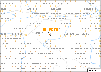
Injerto (El Progreso, Guatemala)Injerto is a town in the El Progreso region of Guatemala. An overview map of the region around Injerto is displayed below.
regional and 3d topo map of Injerto, Guatemala ::
Injerto airports ::
The nearest airport is GUA - Guatemala City La Aurora, located 65.6 km south west of Injerto.
Other airports nearby include CBV - Coban (82.2 km north west), SAL - San Salvador El Salvador Intl (185.3 km south east), Nearby towns ::
El Rejeguero (1.9km south) //
San Rafael (1.9km south) //
Las Joyas (2.6km north east) //
La Palma (2.6km north east) //
Anshagua (2.6km south west) //
Los Encuentros (3.6km east) //
Las Pilas (3.7km south) //
Santa Rita (3.9km west) //
Laguneta (4.1km south east) //
Piedra Ancha (5.4km east) //
Las Peñas (5.6km south) //
Joyas (5.6km south) //
El Naranjo (5.6km south) //
El Paso de los Jalapas (5.8km north) //
Anshigua (6.6km south east) //
Las Ovejas (6.5km north east) //
El Callejón (6.5km north west) //
Pila de los Moscos (7.2km east) //
El Rancho (7.6km north) //
Magdalena (7.6km north) //
La Estrechura (7.6km south) //
El Cedro (7.6km south) //
El Puente (7.6km north) //
Patache (7.7km south west) //
El Jabillo (8.1km north east) //
Santa Gertrudis (8.2km north west) //
El Zapote (9.1km north east) //
Obraje (9.1km south west) //
Chilzapote (9.1km south west) //
[all distances 'as the bird flies' and approximate] 
Disclaimer :: Information on this page comes without warranty of any kind |
||
|
Where is Injerto? Elevation and coordinates ::
Latitude (lat): 14°51'0"N Longitude (lon): 89°59'0"W
Elevation (approx.): 806m (map arrows pan, magnifying glasses zoom) |
||
|
Visiting Injerto? Hotel/Accommodation ::
Book a hotel in Injerto Travel Guide ::
Buy a travel guide for Guatemala rental cars ::
car rental offers GPS waypoint ::
download a GPX waypoint (PoI) of Injerto for your GPS receiver
|
||