|
search place name
|
||
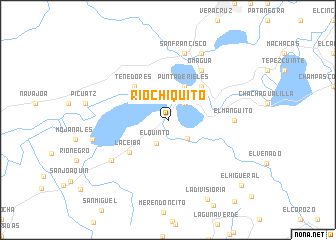
Río Chiquito (Izabal, Guatemala)Río Chiquito is a town in the Izabal region of Guatemala. An overview map of the region around Río Chiquito is displayed below.
regional and 3d topo map of Río Chiquito, Guatemala ::
Río Chiquito airports ::
The nearest airport is SAP - San Pedro Sula La Mesa Intl, located 72.9 km east of Río Chiquito.
Other airports nearby include TEA - Tela (123.9 km east), LCE - La Ceiba Goloson Intl (189.0 km east), CBV - Coban (193.9 km west), TGU - Tegucigalpa Toncontin Intl (219.3 km south east), Nearby towns ::
Buenos Aires (2.6km north east) //
El Quinto (2.9km south west) //
La Esperanza (2.9km south east) //
Punta de Rieles (4.1km north east) //
El Pomo (5.1km north east) //
Tenedores (5.1km north west) //
La Ceiba (5.5km south west) //
Omagua (6.6km north east) //
El Manguito (7.1km east) //
San Francisco (7.6km north) //
La Ceibita (7.5km south west) //
Champona (8.2km north east) //
Guerreros (8.4km west) //
El Higueral (10.8km south east) //
[all distances 'as the bird flies' and approximate]  Places with similar names to Río Chiquito, Guatemala ::
// Rio Chiquito (US)
// Río Chiquito (CO)
// Río Chiquito (CO)
// Río Chiquito (CR)
// Río Chiquito (SV)
// Río Chiquito (GT)
// Río Chiquito (GT)
// Río Chiquito (MX)
// Río Chiquito (MX)
// Río Chiquito (HN)
Disclaimer :: Information on this page comes without warranty of any kind |
||
|
Where is Río Chiquito? Elevation and coordinates ::
Latitude (lat): 15°31'0"N Longitude (lon): 88°36'0"W
Elevation (approx.): 32m (map arrows pan, magnifying glasses zoom) |
||
|
Visiting Río Chiquito? Hotel/Accommodation ::
Book a hotel in Río Chiquito Travel Guide ::
Buy a travel guide for Guatemala rental cars ::
car rental offers GPS waypoint ::
download a GPX waypoint (PoI) of Río Chiquito for your GPS receiver
|
||