|
search place name
|
||
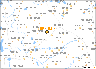
Avancha (Andhra Pradesh, India)Avancha is a town in the Andhra Pradesh region of India. An overview map of the region around Avancha is displayed below.
regional and 3d topo map of Avancha, India ::
Avancha airports ::
The nearest airport is HYD - Hyderabad, located 37.1 km south east of Avancha.
Nearby towns ::
Saiyid Alipet (1.5km east) //
Daulatābād (3.9km west) //
Dawalāpur (4.2km north west) //
Madur (4.4km south east) //
Turkai Khānāpur (4.6km south west) //
Narsāpur (4.8km north east) //
Sadullānagar (4.9km south west) //
Nāgalapalli (5.5km north west) //
Kundāpur (5.7km east) //
Natnayāpalli (6.1km south east) //
Kottaguda (6.6km south) //
Chintalcheru (6.9km south) //
Chandapur (7.0km south west) //
Nāgāwaram (7.3km south east) //
Sikandrapuram (7.4km north west) //
Chapalturti (7.6km north) //
Kāsāl (7.6km west) //
Nārāyanpur (8.1km north east) //
Reddipalli (8.4km north) //
Brahmanguda (8.5km north west) //
Hatnūr (8.5km west) //
Sulakampalli (9.1km south east) //
Bodupatia (9.1km south west) //
Gandlamasnūr (9.4km south west) //
Lingāpuram (9.6km north east) //
Bokaiguda (9.9km south west) //
Nāgaldeopalli (10.1km north west) //
Mangampet (10.7km south east) //
Utla (11.2km south east) //
[all distances 'as the bird flies' and approximate] 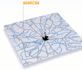 Places with similar names to Avancha, India ::
Disclaimer :: Information on this page comes without warranty of any kind |
||
|
Where is Avancha? Elevation and coordinates ::
Latitude (lat): 17°42'39"N Longitude (lon): 78°14'39"E
Elevation (approx.): 537m (map arrows pan, magnifying glasses zoom) |
||
|
Visiting Avancha? Hotel/Accommodation ::
Book a hotel in Avancha Travel Guide ::
Buy a travel guide for India rental cars ::
car rental offers GPS waypoint ::
download a GPX waypoint (PoI) of Avancha for your GPS receiver
|
||