|
search place name
|
||
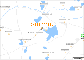
Chettippattu (Tamil Nādu, India)Chettippattu is a town in the Tamil Nādu region of India. An overview map of the region around Chettippattu is displayed below.
regional and 3d topo map of Chettippattu, India ::
Chettippattu airports ::
The nearest airport is MAA - Madras Chennai Intl, located 17.9 km east of Chettippattu.
Other airports nearby include TIR - Tirupeti Tirupati (85.3 km north west), CDP - Cuddapah (213.0 km north west), Nearby towns ::
Kannadiyanpālaiyam (1.8km east) //
Irungattukottai (3.6km south west) //
Menambedu (6.4km north) //
Srīperumbūdūr (9.1km south west) //
[all distances 'as the bird flies' and approximate] 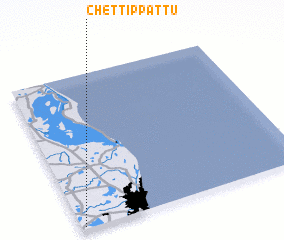 Places with similar names to Chettippattu, India ::
// Chhota Pāta (BD)
// Chhotapota (BD)
// Chetput (IN)
// Chatpat (PK)
// Chhatta Pāda (PK)
// Chetput (IN)
// Chitapata (BO)
// Chutapata (BO)
Disclaimer :: Information on this page comes without warranty of any kind |
||
|
Where is Chettippattu? Elevation and coordinates ::
Latitude (lat): 13°1'0"N Longitude (lon): 80°1'0"E
Elevation (approx.): 26m (map arrows pan, magnifying glasses zoom) |
||
|
Visiting Chettippattu? Hotel/Accommodation ::
Book a hotel in Chettippattu Travel Guide ::
Buy a travel guide for India rental cars ::
car rental offers GPS waypoint ::
download a GPX waypoint (PoI) of Chettippattu for your GPS receiver
|
||