|
search place name
|
||
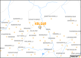
Kalgūr (Andhra Pradesh, India)Kalgūr is a town in the Andhra Pradesh region of India. An overview map of the region around Kalgūr is displayed below.
regional and 3d topo map of Kalgūr, India ::
Kalgūr airports ::
The nearest airport is HYD - Hyderabad, located 61.1 km south west of Kalgūr.
Nearby towns ::
Kishtāpur (2.0km north east) //
Lachhmāpur (3.1km north) //
Dilālpur (3.4km south west) //
Ahmadipur (4.0km south) //
Mantūr (3.9km north west) //
Wamāl (3.9km east) //
Yenkatraopet (4.2km north west) //
Pīrohed (5.3km south) //
Bichgaon (5.2km south west) //
Singātam (5.9km south) //
Lingāpur (5.7km north west) //
Anājpur (5.7km west) //
Pallipahād (6.3km east) //
Anantagiripalli (6.7km north east) //
Tippāram (7.4km south east) //
Boragpalli (8.2km south east) //
Yarapalli (8.0km south east) //
Pirlāpalli (8.5km south west) //
Raipol (8.4km west) //
Bayaram (9.1km south) //
Kuttapalli (9.2km south west) //
[all distances 'as the bird flies' and approximate]  Places with similar names to Kalgūr, India ::
// Kilgore (US)
// Calgro (US)
// Kelker (US)
// Kalkar (DE)
// Kalkar (DE)
// Kilgore (US)
// Kuala Kerai (MY)
// Kuala Kerau (MY)
// Kuala Kurau (MY)
// Calcara (IT)
Disclaimer :: Information on this page comes without warranty of any kind |
||
|
Where is Kalgūr? Elevation and coordinates ::
Latitude (lat): 17°57'21"N Longitude (lon): 78°42'22"E
Elevation (approx.): 526m (map arrows pan, magnifying glasses zoom) |
||
|
Visiting Kalgūr? Hotel/Accommodation ::
Book a hotel in Kalgūr Travel Guide ::
Buy a travel guide for India rental cars ::
car rental offers GPS waypoint ::
download a GPX waypoint (PoI) of Kalgūr for your GPS receiver
|
||