|
search place name
|
||
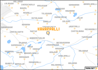
Kawārpalli (Andhra Pradesh, India)Kawārpalli is a town in the Andhra Pradesh region of India. An overview map of the region around Kawārpalli is displayed below.
regional and 3d topo map of Kawārpalli, India ::
Kawārpalli airports ::
The nearest airport is HYD - Hyderabad, located 25.8 km north west of Kawārpalli.
Nearby towns ::
Tardmatipeta (2.3km north) //
Abdullapur (2.5km south east) //
Gorelli (4.4km north) //
Lashkarguda (4.8km south) //
Ambarpet Kalān (4.6km south west) //
Kuntūr (5.6km west) //
Kotlapuram (6.0km north west) //
Bātāsingāram (6.5km south east) //
Pilgamma (6.8km south east) //
Mutialguda (7.1km north west) //
Masidpur (7.2km south east) //
Telugūdam (7.5km north) //
Rairāl Kalān (7.4km north east) //
Anājpur (7.6km south) //
Koheda (7.7km south west) //
Golegal (7.9km north east) //
Hayātnagar (7.9km west) //
Tarūr (8.6km south west) //
Annāram (8.9km west) //
Bahmanlapalli (10.0km south west) //
Niralapalli (10.4km south east) //
Medpalli (10.9km north west) //
Mādhāram (11.5km north east) //
[all distances 'as the bird flies' and approximate] 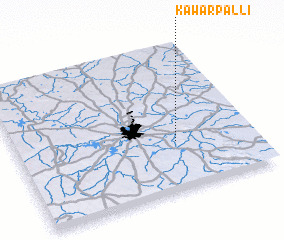 Places with similar names to Kawārpalli, India ::
// Khwārpalai (PK)
Disclaimer :: Information on this page comes without warranty of any kind |
||
|
Where is Kawārpalli? Elevation and coordinates ::
Latitude (lat): 17°20'12"N Longitude (lon): 78°40'39"E
Elevation (approx.): 480m (map arrows pan, magnifying glasses zoom) |
||
|
Visiting Kawārpalli? Hotel/Accommodation ::
Book a hotel in Kawārpalli Travel Guide ::
Buy a travel guide for India rental cars ::
car rental offers GPS waypoint ::
download a GPX waypoint (PoI) of Kawārpalli for your GPS receiver
|
||