|
search place name
|
||
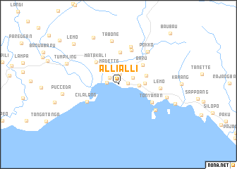
Allialli (Sulawesi Selatan, Indonesia)Allialli is a town in the Sulawesi Selatan region of Indonesia. An overview map of the region around Allialli is displayed below.
regional and 3d topo map of Allialli, Indonesia ::
Allialli airports ::
The nearest airport is UPG - Ujung Pandang Hasanuddin, located 182.2 km south of Allialli.
Nearby towns ::
Pajala (1.5km east) //
Takatidung (1.7km north) //
Mandi (1.8km north west) //
Rumpa (1.8km west) //
Polewali (2.3km north) //
Patoke (2.5km north east) //
Madette (2.9km north west) //
Lantora (3.3km east) //
Tanro (4.2km east) //
Mammi (4.6km east) //
Baru (4.9km north east) //
Matakali (5.0km north west) //
Baseang (5.1km north) //
Cilalang (5.7km south west) //
Kunyi (5.8km north) //
Tonyaman (6.0km south east) //
Beluak (6.3km north) //
Lemo (6.7km east) //
Tabone (6.9km north) //
Pokko (6.9km north east) //
Masina (7.1km south east) //
Binuang (7.9km east) //
Katumbangun (8.5km north west) //
Tumpiling (8.9km west) //
Pucceda (9.0km west) //
Lemo (9.6km north west) //
Baubau (11.5km north east) //
[all distances 'as the bird flies' and approximate] 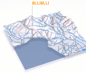 Places with similar names to Allialli, Indonesia ::
Disclaimer :: Information on this page comes without warranty of any kind |
||
|
Where is Allialli? Elevation and coordinates ::
Latitude (lat): 3°25'54"S Longitude (lon): 119°18'53"E
Elevation (approx.): -32768m (map arrows pan, magnifying glasses zoom) |
||
|
Visiting Allialli? Hotel/Accommodation ::
Book a hotel in Allialli Travel Guide ::
Buy a travel guide for Indonesia rental cars ::
car rental offers GPS waypoint ::
download a GPX waypoint (PoI) of Allialli for your GPS receiver
|
||