|
search place name
|
||
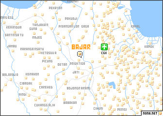
Bajar (Indonesia)Bajar is a town in Indonesia. An overview map of the region around Bajar is displayed below.
regional and 3d topo map of Bajar, Indonesia ::
Bajar airports ::
The nearest airport is CGK - Jakarta Soekarno Hatta Intl, located 5.9 km north east of Bajar.
Nearby towns ::
Nagrak (0.8km south west) //
Priuk Tiga (2.5km south) //
Kedawung-wetan (2.5km north east) //
Parungkuda (2.6km east) //
Pasarbaru (3.0km south east) //
Kedawang Kulon (3.0km north) //
Gelo (3.5km south) //
Buaran (4.2km north) //
Kampungutan (4.2km east) //
Tangerang (4.2km south east) //
Selapajang (4.5km north east) //
Jati (4.5km south) //
Sepatan (4.6km north west) //
Kola (4.7km north) //
Kampungkosong (4.7km east) //
Tegalglagah (4.7km north east) //
Kampungteko (4.9km east) //
Oetan (4.9km south west) //
Rawagempol (5.0km north) //
Karawaci (5.2km south) //
Kongsibaru (5.3km north east) //
Bugel (5.3km west) //
Cibodas (5.3km south) //
Tanahtinggi (5.3km south east) //
Rawakatipes (5.4km north east) //
Belendung (5.4km east) //
Bubulakbug (5.4km west) //
Gembor (5.5km south west) //
Kober (5.6km south east) //
[all distances 'as the bird flies' and approximate]  Places with similar names to Bajar, Indonesia ::
Disclaimer :: Information on this page comes without warranty of any kind |
||
|
Where is Bajar? Elevation and coordinates ::
Latitude (lat): 6°8'52"S Longitude (lon): 106°36'28"E
Elevation (approx.): 14m (map arrows pan, magnifying glasses zoom) |
||
|
Visiting Bajar? Hotel/Accommodation ::
Book a hotel in Bajar Travel Guide ::
Buy a travel guide for Indonesia rental cars ::
car rental offers GPS waypoint ::
download a GPX waypoint (PoI) of Bajar for your GPS receiver
|
||