|
search place name
|
||
Bener (Indonesia)Bener is a town in Indonesia. An overview map of the region around Bener is displayed below.
regional and 3d topo map of Bener, Indonesia ::

Nearby towns ::
Munggangsari (0.0km north) //
Ranousari (1.9km north) //
Gadingan (1.9km south) //
Wonorejo (2.6km north west) //
Kerjo (3.7km east) //
Jumbeng (4.1km south east) //
Gemenggeng (4.1km south east) //
Kepil (4.1km north west) //
Doplang (4.1km south west) //
Batur (4.1km south west) //
Dlisen (5.2km south west) //
Kenteng (5.2km south west) //
Ngadirojo (5.5km west) //
Tunggangan (5.5km east) //
Laris (5.6km south) //
Kaliwulun (5.9km north) //
Kaliabu (5.8km east) //
Margoyoso (6.6km south east) //
Buluduwur (7.6km north) //
Kajoran (7.6km east) //
Legetan (7.6km south) //
Kemiri (7.6km south) //
Sumoleter (7.8km south west) //
Talunombo (8.3km north west) //
Kalijambe (8.3km south east) //
Kalikarung (8.2km north west) //
Sapuran (9.2km north west) //
Sutopat (10.4km north east) //
[all distances 'as the bird flies' and approximate] 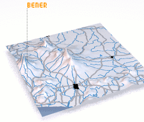 Places with similar names to Bener, Indonesia ::
Disclaimer :: Information on this page comes without warranty of any kind |
||
|
Where is Bener? Elevation and coordinates ::
Latitude (lat): 7°32'0"S Longitude (lon): 110°1'0"E
Elevation (approx.): 474m (map arrows pan, magnifying glasses zoom) |
||
|
Visiting Bener? Hotel/Accommodation ::
Book a hotel in Bener Travel Guide ::
Buy a travel guide for Indonesia rental cars ::
car rental offers GPS waypoint ::
download a GPX waypoint (PoI) of Bener for your GPS receiver
|
||