|
search place name
|
||
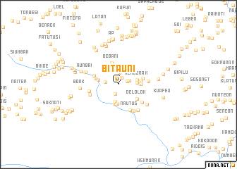
Bitauni (Indonesia)Bitauni is a town in Indonesia. An overview map of the region around Bitauni is displayed below.
regional and 3d topo map of Bitauni, Indonesia ::
Bitauni airports ::
The nearest airport is DIL - Dili Presidente Nicolau Lobato Intl, located 136.9 km north east of Bitauni.
Nearby towns ::
Naikofi (1.2km north east) //
Finikleu (1.4km east) //
Besain (1.6km south) //
Nesam (1.8km east) //
Uskono (1.9km north) //
Noenebu (2.1km west) //
Musimasu (2.2km north) //
Naimasu (2.5km north) //
Geleja (2.7km south) //
Sapan (2.9km east) //
Nenbonak (3.0km east) //
Nefomtasa (3.1km south) //
Fatukumolo (3.1km south) //
Fafasu (3.2km north) //
Netefoko (3.2km west) //
Kiupukan (3.5km east) //
Nispukan (3.5km east) //
Oebani (3.6km north) //
Oelolok (3.7km south east) //
Oeliurai (3.7km west) //
Haufoo (3.9km east) //
Petu (4.0km west) //
Nautus (4.5km south east) //
Buta (4.7km south east) //
Fatoin (4.7km east) //
Sekon (4.7km west) //
Banlunas (4.7km west) //
Boni (4.8km south east) //
Oekato (5.1km south east) //
[all distances 'as the bird flies' and approximate]  Places with similar names to Bitauni, Indonesia ::
Disclaimer :: Information on this page comes without warranty of any kind |
||
|
Where is Bitauni? Elevation and coordinates ::
Latitude (lat): 9°26'54"S Longitude (lon): 124°40'18"E
Elevation (approx.): 390m (map arrows pan, magnifying glasses zoom) |
||
|
Visiting Bitauni? Hotel/Accommodation ::
Book a hotel in Bitauni Travel Guide ::
Buy a travel guide for Indonesia rental cars ::
car rental offers GPS waypoint ::
download a GPX waypoint (PoI) of Bitauni for your GPS receiver
|
||