|
search place name
|
||
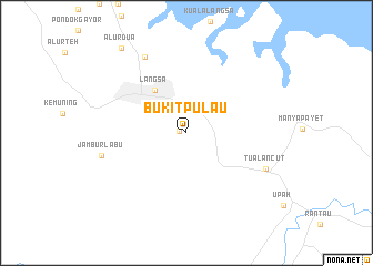
Bukitpulau (Aceh, Indonesia)Bukitpulau is a town in the Aceh region of Indonesia. An overview map of the region around Bukitpulau is displayed below.
regional and 3d topo map of Bukitpulau, Indonesia ::
Bukitpulau airports ::
The nearest airport is MES - Medan Polonia, located 122.5 km south east of Bukitpulau.
Other airports nearby include LGK - Pulau Langkawi Intl (284.4 km north east), Nearby towns ::
Afdeling II Bukit (0.7km west) //
Asembetik (1.3km north west) //
Langsa (5.4km north west) //
Birimpontong (8.7km north west) //
Tualancut (8.7km south east) //
Jamburlabu (8.9km west) //
Alurdua (10.8km north west) //
[all distances 'as the bird flies' and approximate] 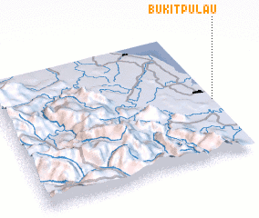 Places with similar names to Bukitpulau, Indonesia ::
// Bagdapalli (IN)
// Bačka Topola (CS)
Disclaimer :: Information on this page comes without warranty of any kind |
||
|
Where is Bukitpulau? Elevation and coordinates ::
Latitude (lat): 4°25'58"N Longitude (lon): 97°59'43"E
Elevation (approx.): 8m (map arrows pan, magnifying glasses zoom) |
||
|
Visiting Bukitpulau? Hotel/Accommodation ::
Book a hotel in Bukitpulau Travel Guide ::
Buy a travel guide for Indonesia rental cars ::
car rental offers GPS waypoint ::
download a GPX waypoint (PoI) of Bukitpulau for your GPS receiver
|
||