|
search place name
|
||
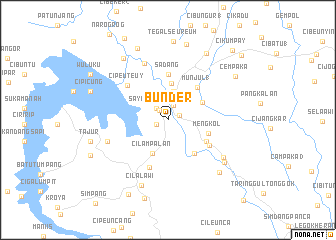
Bunder (Indonesia)Bunder is a town in Indonesia. An overview map of the region around Bunder is displayed below.
regional and 3d topo map of Bunder, Indonesia ::
Bunder airports ::
The nearest airport is CGK - Jakarta Soekarno Hatta Intl, located 98.1 km north west of Bunder.
Nearby towns ::
Ciganea (1.3km south west) //
Purwakarta (1.3km north east) //
Jatiluhur (1.4km north west) //
Cigombrong (1.7km north) //
Sayangheulang (1.8km north west) //
Maracang-tua (3.2km north) //
Cilampalan (4.1km south west) //
Pasarsenen (4.1km north) //
Citalang 2 (4.3km north east) //
Selakaya (4.7km south east) //
Mengkol (4.8km east) //
Munjul 1 (4.9km north east) //
Cihideung (4.9km south east) //
Sadang (5.0km north) //
Pasawahan (5.4km south east) //
Bendul 1 (5.7km south) //
Cipeuteuy (5.9km north west) //
Cikaobandung 1 (6.8km north) //
Ciseuti (7.2km west) //
Pondoksalam (7.5km south east) //
Cilalawi (7.8km south) //
Pondokgede (7.9km south east) //
Tanjungsari (8.1km south east) //
Batulayang (8.5km north west) //
Gurungsang (8.6km north east) //
Ciharashas (8.7km north) //
Nagrok (8.7km north west) //
Tegalseureuh (8.8km north) //
Tajur (8.9km west) //
[all distances 'as the bird flies' and approximate]  Places with similar names to Bunder, Indonesia ::
// Beni Idder (MA)
// Beni Idir (MA)
// Beni Idir (MA)
// Bou Antar (MA)
// Boû Ouentere (MA)
// Bandīra (ET)
// Bander (ET)
// Bañadero (PH)
// Bañadero (PH)
// Bañadero (PH)
Disclaimer :: Information on this page comes without warranty of any kind |
||
|
Where is Bunder? Elevation and coordinates ::
Latitude (lat): 6°33'43"S Longitude (lon): 107°25'40"E
Elevation (approx.): 84m (map arrows pan, magnifying glasses zoom) |
||
|
Visiting Bunder? Hotel/Accommodation ::
Book a hotel in Bunder Travel Guide ::
Buy a travel guide for Indonesia rental cars ::
car rental offers GPS waypoint ::
download a GPX waypoint (PoI) of Bunder for your GPS receiver
|
||