|
search place name
|
||
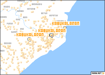
Kabukalaran (Nusa Tenggara Timur, Indonesia)Kabukalaran is a town in the Nusa Tenggara Timur region of Indonesia. An overview map of the region around Kabukalaran is displayed below.
regional and 3d topo map of Kabukalaran, Indonesia ::
Kabukalaran airports ::
The nearest airport is DIL - Dili Presidente Nicolau Lobato Intl, located 136.8 km north east of Kabukalaran.
Nearby towns ::
Kabukalaran (0.1km west) //
Merobo (0.5km north east) //
Merobo (0.5km north east) //
Loomatalalabesin B (0.6km south west) //
Ketara (0.7km south west) //
Loomatalalabesin B (0.7km south west) //
Ketara (0.8km south west) //
Umatoos B (0.8km south east) //
Umatoos B (0.8km south) //
Leorae (0.9km north) //
Leorae (1.0km north) //
Leorai (1.2km north) //
Fafoe (1.2km south) //
Fafoe (1.2km south) //
Airae (1.3km north east) //
Airae (1.4km north east) //
Beikolo (1.5km south west) //
Debunaruk (1.5km west) //
Lukuloweain 2 (1.5km north) //
Beikolo (1.5km south west) //
Lasaen (1.6km south west) //
Lainblidin (1.7km north west) //
Misi (1.8km south) //
Lasaen (1.8km south west) //
Toaskiar (1.8km north) //
Besikama Utara (1.8km south west) //
Debunaruk (1.8km west) //
Sukabilulik (1.8km north east) //
Lainblidin (1.8km north west) //
[all distances 'as the bird flies' and approximate] 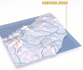 Places with similar names to Kabukalaran, Indonesia ::
Disclaimer :: Information on this page comes without warranty of any kind |
||
|
Where is Kabukalaran? Elevation and coordinates ::
Latitude (lat): 9°38'5"S Longitude (lon): 124°55'56"E
Elevation (approx.): 9m (map arrows pan, magnifying glasses zoom) |
||
|
Visiting Kabukalaran? Hotel/Accommodation ::
Book a hotel in Kabukalaran Travel Guide ::
Buy a travel guide for Indonesia rental cars ::
car rental offers GPS waypoint ::
download a GPX waypoint (PoI) of Kabukalaran for your GPS receiver
|
||