|
search place name
|
||
Langkuta (Indonesia)Langkuta is a town in Indonesia. An overview map of the region around Langkuta is displayed below.
regional and 3d topo map of Langkuta, Indonesia ::

Langkuta airports ::
The nearest airport is BTJ - Banda Aceh Sultan Iskandarmuda, located 55.4 km west of Langkuta.
Nearby towns ::
Baurabo (2.6km north west) //
Calongreyeu (3.7km north) //
Labuy (4.1km south east) //
Bidaya (4.1km south west) //
Geunteng (4.1km north east) //
Rangkeuem (4.1km north west) //
Sigli (5.5km east) //
Rungkum (5.6km north) //
Beuah (5.6km south) //
Crung (5.5km west) //
Karedeng (6.7km north west) //
Kunyet (6.7km south west) //
Padangtiji (7.6km west) //
Lanjong (7.6km west) //
Kulam (7.6km north) //
Kaju (7.8km south east) //
Buhueklaiu (9.2km south east) //
[all distances 'as the bird flies' and approximate] 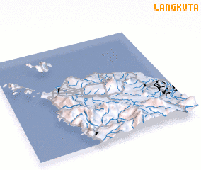 Places with similar names to Langkuta, Indonesia ::
// Laingkat (US)
// Langquaid (DE)
// Lingkudau (MY)
// Lungkat (MY)
// Langkadi (ID)
// Lingogoto (SN)
// Languékoto (ML)
// Linguékoto (ML)
// Linguékoto (ML)
// Linguékoto (ML)
Disclaimer :: Information on this page comes without warranty of any kind |
||
|
Where is Langkuta? Elevation and coordinates ::
Latitude (lat): 5°23'0"N Longitude (lon): 95°54'0"E
Elevation (approx.): 21m (map arrows pan, magnifying glasses zoom) |
||
|
Visiting Langkuta? Hotel/Accommodation ::
Book a hotel in Langkuta Travel Guide ::
Buy a travel guide for Indonesia rental cars ::
car rental offers GPS waypoint ::
download a GPX waypoint (PoI) of Langkuta for your GPS receiver
|
||