|
search place name
|
||
Lukoi (Nusa Tenggara Timur, Indonesia)Lukoi is a town in the Nusa Tenggara Timur region of Indonesia. An overview map of the region around Lukoi is displayed below.
regional and 3d topo map of Lukoi, Indonesia ::

Lukoi airports ::
The nearest airport is DIL - Dili Presidente Nicolau Lobato Intl, located 68.0 km north east of Lukoi.
Nearby towns ::
Dilagusun (0.4km south east) //
Builalu (0.5km south east) //
Rusan (0.5km south) //
Memoli (0.6km south west) //
Nakalolo (0.8km west) //
Sibil (1.6km north) //
Holso (1.7km south east) //
Poti (2.0km south east) //
Tahon (2.0km south east) //
Dilumil (2.4km north east) //
Maululin (2.6km north west) //
Saburaka (2.6km south west) //
Juldapil (2.8km south east) //
Hokon (3.6km north) //
Boasuin (3.6km north west) //
Huluatin (4.0km north east) //
Memo (4.1km north east) //
Mahui (4.2km south) //
Fohomeak (4.2km north west) //
Kotakfau (4.2km west) //
Silala (4.2km south) //
Simugol (4.2km east) //
Asueman (4.3km south west) //
Pipgalak 1 (4.4km north east) //
Derok (4.7km north west) //
Horen (4.8km south) //
Lepguen (4.8km north east) //
Lisuaben (4.8km north west) //
Luagujul (5.0km south) //
[all distances 'as the bird flies' and approximate] 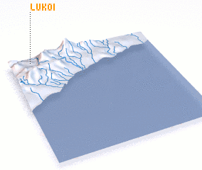 Places with similar names to Lukoi, Indonesia ::
Disclaimer :: Information on this page comes without warranty of any kind |
||
|
Where is Lukoi? Elevation and coordinates ::
Latitude (lat): 9°2'17"S Longitude (lon): 125°9'12"E
Elevation (approx.): 251m (map arrows pan, magnifying glasses zoom) |
||
|
Visiting Lukoi? Hotel/Accommodation ::
Book a hotel in Lukoi Travel Guide ::
Buy a travel guide for Indonesia rental cars ::
car rental offers GPS waypoint ::
download a GPX waypoint (PoI) of Lukoi for your GPS receiver
|
||