|
search place name
|
||
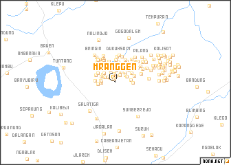
Mranggen (Jawa Tengah, Indonesia)Mranggen is a town in the Jawa Tengah region of Indonesia. An overview map of the region around Mranggen is displayed below.
regional and 3d topo map of Mranggen, Indonesia ::
Nearby towns ::
Bejaten (0.6km north west) //
Beton (0.7km north) //
Giling (1.1km north) //
Kalongan (1.1km north west) //
Baruan (1.4km north east) //
Padaan (1.4km north) //
Kauman Lor (1.5km north west) //
Karangguli (1.7km north west) //
Macanan (1.9km north west) //
Gondanglegi (1.9km north east) //
Slemet (2.0km north) //
Bungas (2.0km north east) //
Wonolelo (2.0km north east) //
Ngasinan (2.1km north west) //
Ngablak (2.2km north east) //
Karangrejo (2.2km west) //
Cikalan (2.4km north) //
Kadipiro (2.4km north west) //
Beran (2.4km north west) //
Ploso (2.4km west) //
Trawungan (2.5km west) //
Tawangsari (2.6km east) //
Takan Lor (2.8km west) //
Gambit (2.9km east) //
Carikan (2.9km north east) //
Grogol (3.0km north east) //
Popongan (3.2km north) //
Karangtengah (3.2km north west) //
Gunungcengis (3.3km east) //
[all distances 'as the bird flies' and approximate] 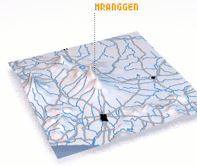 Places with similar names to Mranggen, Indonesia ::
Disclaimer :: Information on this page comes without warranty of any kind |
||
|
Where is Mranggen? Elevation and coordinates ::
Latitude (lat): 7°17'24"S Longitude (lon): 110°31'49"E
Elevation (approx.): 470m (map arrows pan, magnifying glasses zoom) |
||
|
Visiting Mranggen? Hotel/Accommodation ::
Book a hotel in Mranggen Travel Guide ::
Buy a travel guide for Indonesia rental cars ::
car rental offers GPS waypoint ::
download a GPX waypoint (PoI) of Mranggen for your GPS receiver
|
||