|
search place name
|
||
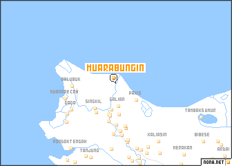
Muarabungin (Indonesia)Muarabungin is a town in Indonesia. An overview map of the region around Muarabungin is displayed below.
regional and 3d topo map of Muarabungin, Indonesia ::
Muarabungin airports ::
The nearest airport is CGK - Jakarta Soekarno Hatta Intl, located 52.6 km west of Muarabungin.
Nearby towns ::
Galian (3.8km south) //
Pakis (4.2km south east) //
Kalimati (4.4km south) //
Babakan (5.1km south) //
Cabangbungin (5.2km south) //
Sungaimerah (5.2km south) //
Singkil (5.3km south west) //
Kedawung (5.4km south) //
Kampunganyar (5.7km south west) //
Kampungblakang (6.3km south) //
Kelapadua (6.8km south) //
Balubuk (7.1km west) //
Selokan-nangkadua (7.2km south) //
Babakan-kidul (7.5km south) //
Kenangadua (7.8km south) //
Kalibaru (8.2km south) //
Gaga (8.3km south west) //
Tanahbaru Satu (8.5km south) //
Muarapecah (8.6km west) //
Kampungbaru (9.3km south west) //
Muaragembong (10.2km south west) //
[all distances 'as the bird flies' and approximate]  Places with similar names to Muarabungin, Indonesia :: Disclaimer :: Information on this page comes without warranty of any kind |
||
|
Where is Muarabungin? Elevation and coordinates ::
Latitude (lat): 5°56'55"S Longitude (lon): 107°5'48"E
Elevation (approx.): 2m (map arrows pan, magnifying glasses zoom) |
||
|
Visiting Muarabungin? Hotel/Accommodation ::
Book a hotel in Muarabungin Travel Guide ::
Buy a travel guide for Indonesia rental cars ::
car rental offers GPS waypoint ::
download a GPX waypoint (PoI) of Muarabungin for your GPS receiver
|
||