|
search place name
|
||
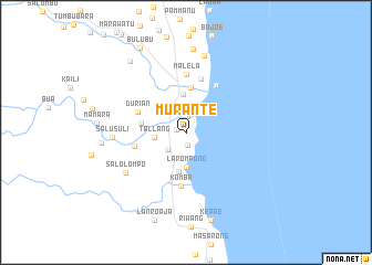
Murante (Sulawesi Selatan, Indonesia)Murante is a town in the Sulawesi Selatan region of Indonesia. An overview map of the region around Murante is displayed below.
regional and 3d topo map of Murante, Indonesia ::
Murante airports ::
The nearest airport is UPG - Ujung Pandang Hasanuddin, located 198.0 km south west of Murante.
Nearby towns ::
Buntu (1.0km west) //
Tiwondu (1.3km south) //
Botta (1.6km north) //
Pasampang (2.6km south west) //
Lempokasi (2.7km north) //
Tallang (3.2km west) //
Larompong (3.5km south) //
Salama (3.9km north) //
Lumaring (4.0km south) //
Pusung (4.5km north) //
Babakalo (4.7km west) //
Durian (5.3km north west) //
Tobolong (5.4km west) //
Komba (5.4km south) //
Cimpu (5.6km north) //
Cimpumuara Utara (5.7km north east) //
Malela (5.9km north) //
Salolompo (7.3km south west) //
Salu Suli (7.4km west) //
Talumai (8.0km north) //
Mangaliali (8.4km north) //
Lindajang (8.5km west) //
Pandoso (9.2km north west) //
Keppe (9.2km south) //
Lanroaja (9.4km south) //
Bulubu (9.7km north west) //
[all distances 'as the bird flies' and approximate] 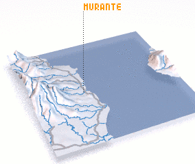 Places with similar names to Murante, Indonesia ::
Disclaimer :: Information on this page comes without warranty of any kind |
||
|
Where is Murante? Elevation and coordinates ::
Latitude (lat): 3°28'21"S Longitude (lon): 120°22'31"E
Elevation (approx.): 9m (map arrows pan, magnifying glasses zoom) |
||
|
Visiting Murante? Hotel/Accommodation ::
Book a hotel in Murante Travel Guide ::
Buy a travel guide for Indonesia rental cars ::
car rental offers GPS waypoint ::
download a GPX waypoint (PoI) of Murante for your GPS receiver
|
||