|
search place name
|
||
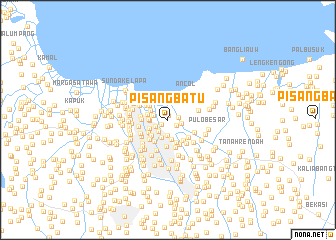
Pisangbatu (Indonesia)Pisangbatu is a town in Indonesia. An overview map of the region around Pisangbatu is displayed below.
regional and 3d topo map of Pisangbatu, Indonesia ::
Pisangbatu airports ::
The nearest airport is CGK - Jakarta Soekarno Hatta Intl, located 20.6 km west of Pisangbatu.
Nearby towns ::
Pademangan (0.5km north) //
Jembatanmerah (0.9km south west) //
Serdang (1.2km south east) //
Bendungan-jambon (1.2km east) //
Sunter (1.5km east) //
Tamansari (1.6km south west) //
Pintubesi (1.7km south west) //
Yakatra (1.7km west) //
Kampungjawa (1.8km south) //
Manggabesar (2.0km west) //
Pasarbaru (2.1km south) //
Tangki (2.1km west) //
Gatep (2.2km north west) //
Kemayoran (2.2km south) //
Pesayuran (2.3km south west) //
Pecahkulit (2.3km west) //
Sawahbesar (2.5km south west) //
Kebonjeruk (2.6km south west) //
Muaraancol (2.6km north west) //
Kantorkawat (2.6km north west) //
Pekapuran (2.6km north west) //
Kamo (2.7km south) //
Pecenongan (2.8km south west) //
Kemayoran-wetan (2.8km south east) //
Bandan (2.9km north west) //
Klenteng (2.9km west) //
Kepuh (3.0km south east) //
Tanah Nyonya (3.0km south) //
Kemayorangempol (3.0km south east) //
[all distances 'as the bird flies' and approximate] 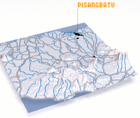 Places with similar names to Pisangbatu, Indonesia ::
// Pisangbatu (ID)
// Pisangbatu (ID)
Disclaimer :: Information on this page comes without warranty of any kind |
||
|
Where is Pisangbatu? Elevation and coordinates ::
Latitude (lat): 6°8'39"S Longitude (lon): 106°50'29"E
Elevation (approx.): 5m (map arrows pan, magnifying glasses zoom) |
||
|
Visiting Pisangbatu? Hotel/Accommodation ::
Book a hotel in Pisangbatu Travel Guide ::
Buy a travel guide for Indonesia rental cars ::
car rental offers GPS waypoint ::
download a GPX waypoint (PoI) of Pisangbatu for your GPS receiver
|
||