|
search place name
|
||
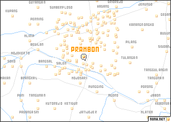
Prambon (Jawa Timur, Indonesia)Prambon is a town in the Jawa Timur region of Indonesia. An overview map of the region around Prambon is displayed below.
regional and 3d topo map of Prambon, Indonesia ::
Nearby towns ::
Nambangan (0.8km south west) //
Bangun (0.9km south) //
Kalitengah (1.6km south east) //
Gedangrowo (1.6km east) //
Ngrame (1.9km south) //
Ngemplak (1.9km west) //
Pulosari (2.0km west) //
Gading (2.1km south) //
Ploso (2.1km south east) //
Kedungkudi (2.4km south west) //
Gembongan (2.6km south) //
Bendotretok (2.9km north) //
Balongcangak (3.1km south west) //
Mergojog (3.1km west) //
Jotangan (3.2km south) //
Klinter (3.3km north west) //
Lemiring (3.4km west) //
Temu Satu (3.5km north east) //
Simpang (3.6km east) //
Bangsri (3.7km south west) //
Pohjejer (3.9km south east) //
Kedinding (3.9km north) //
Kwatu (4.0km west) //
Jatisari (4.3km north west) //
Bandilan (4.5km north east) //
Sekelor Utara (4.5km north) //
Gedang (4.5km south west) //
Guyangan (4.5km north) //
Jenjen (4.5km north east) //
[all distances 'as the bird flies' and approximate] 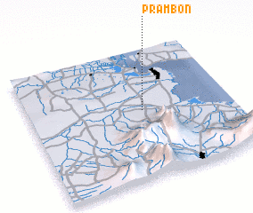 Places with similar names to Prambon, Indonesia ::
Disclaimer :: Information on this page comes without warranty of any kind |
||
|
Where is Prambon? Elevation and coordinates ::
Latitude (lat): 7°28'21"S Longitude (lon): 112°33'37"E
Elevation (approx.): 16m (map arrows pan, magnifying glasses zoom) |
||
|
Visiting Prambon? Hotel/Accommodation ::
Book a hotel in Prambon Travel Guide ::
Buy a travel guide for Indonesia rental cars ::
car rental offers GPS waypoint ::
download a GPX waypoint (PoI) of Prambon for your GPS receiver
|
||