|
search place name
|
||
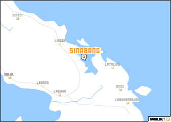
Sinabang (Aceh, Indonesia)Sinabang is a town in the Aceh region of Indonesia. An overview map of the region around Sinabang is displayed below.
regional and 3d topo map of Sinabang, Indonesia ::
Sinabang airports ::
The nearest airport is GNS - Gunung Sitoli Binaka, located 206.9 km south east of Sinabang.
Nearby towns ::
 Places with similar names to Sinabang, Indonesia ::
// Seinbaung (MM)
// Sunnybank (US)
// Sunnybank (US)
// Senibung (ID)
// Sanbanga (GH)
// Sini Bangou (NE)
// Sini Bangou (NE)
// Sanbong (KP)
// Sanbang (KR)
// Sinbang (KR)
Disclaimer :: Information on this page comes without warranty of any kind |
||
|
Where is Sinabang? Elevation and coordinates ::
Latitude (lat): 2°29'0"N Longitude (lon): 96°23'0"E
Elevation (approx.): -32768m (map arrows pan, magnifying glasses zoom) |
||
|
Visiting Sinabang? Hotel/Accommodation ::
Book a hotel in Sinabang Travel Guide ::
Buy a travel guide for Indonesia rental cars ::
car rental offers GPS waypoint ::
download a GPX waypoint (PoI) of Sinabang for your GPS receiver
|
||