|
search place name
|
||
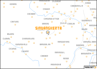
Sindangkerta (Jawa Barat, Indonesia)Sindangkerta is a town in the Jawa Barat region of Indonesia. An overview map of the region around Sindangkerta is displayed below.
regional and 3d topo map of Sindangkerta, Indonesia ::
Sindangkerta airports ::
The nearest airport is CGK - Jakarta Soekarno Hatta Intl, located 125.7 km north west of Sindangkerta.
Nearby towns ::
Malaka (1.4km south) //
Cisandawut (1.7km south west) //
Rancapanggung (2.6km east) //
Cijenuk (2.7km west) //
Wareng (3.2km north) //
Bojongloa (3.7km south) //
Bongas (3.7km north east) //
Pasirmalang Tiga (4.3km east) //
Cipeundeuy Tiga (5.1km north) //
Barusalam (5.1km south) //
Cipongkor (5.4km north west) //
Celak (6.5km south west) //
Cililin (6.6km north east) //
Nanggerang (7.1km south east) //
Sukatengah (7.4km north) //
Cikarundung (8.1km west) //
Cicalengka Dua (8.5km north east) //
Cisudim (8.8km north) //
Rancairung (9.1km north east) //
Naringgul (9.3km south east) //
Cacaban (9.3km north west) //
Kandangsapi (9.8km north east) //
Cihampelas (10.2km north east) //
Pangauban Satu (10.3km north east) //
Cikuray (11.5km south west) //
Cangkorah (12.4km north east) //
Pasirpaku (12.4km north east) //
[all distances 'as the bird flies' and approximate] 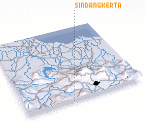 Places with similar names to Sindangkerta, Indonesia :: Disclaimer :: Information on this page comes without warranty of any kind |
||
|
Where is Sindangkerta? Elevation and coordinates ::
Latitude (lat): 6°58'48"S Longitude (lon): 107°24'18"E
Elevation (approx.): 678m (map arrows pan, magnifying glasses zoom) |
||
|
Visiting Sindangkerta? Hotel/Accommodation ::
Book a hotel in Sindangkerta Travel Guide ::
Buy a travel guide for Indonesia rental cars ::
car rental offers GPS waypoint ::
download a GPX waypoint (PoI) of Sindangkerta for your GPS receiver
|
||