|
search place name
|
||
Tangunan (Indonesia)Tangunan is a town in Indonesia. An overview map of the region around Tangunan is displayed below.
regional and 3d topo map of Tangunan, Indonesia ::

Nearby towns ::
Dilanggu (1.9km south) //
Puri (3.7km west) //
Kutorejo (4.1km south east) //
Badung (4.1km south east) //
Dinoyo (4.1km south west) //
Brangkal (4.1km north west) //
Padangasri (4.1km south west) //
Gondang (5.9km south) //
Karanglo (5.9km south) //
Pugeran (6.7km south east) //
Payungrejo (6.7km south east) //
Buaksempu (6.6km south west) //
Sawahan (6.9km north east) //
Pendowo (7.5km north east) //
Ketidur (7.6km east) //
Bangsal (7.6km north) //
Pandan (7.8km south east) //
Pekuwon (8.1km north east) //
Ngranggon (8.3km north east) //
Gemakan (8.2km north west) //
Kranggan (8.3km north west) //
Salen (8.8km north east) //
Gedang (9.0km north east) //
Semanggi (9.2km north east) //
Soko (9.2km north west) //
Jatirejo (9.2km south west) //
Bangsri (9.8km north east) //
Balongcangak (10.4km north east) //
Sambiroto-kulon (10.4km north west) //
[all distances 'as the bird flies' and approximate] 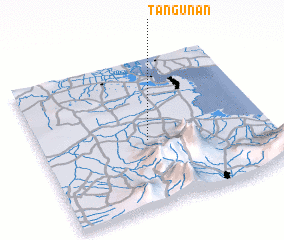 Places with similar names to Tangunan, Indonesia ::
// Danganan (PH)
// Danganon (PH)
// Dinganen (PH)
// Tongonina (CU)
// Tînganu Nou (RO)
// Tangainony (MG)
// Tanganony (MG)
// Duncanon (US)
// Dungannon (US)
// Dungannon (US)
Disclaimer :: Information on this page comes without warranty of any kind |
||
|
Where is Tangunan? Elevation and coordinates ::
Latitude (lat): 7°33'0"S Longitude (lon): 112°28'0"E
Elevation (approx.): 65m (map arrows pan, magnifying glasses zoom) |
||
|
Visiting Tangunan? Hotel/Accommodation ::
Book a hotel in Tangunan Travel Guide ::
Buy a travel guide for Indonesia rental cars ::
car rental offers GPS waypoint ::
download a GPX waypoint (PoI) of Tangunan for your GPS receiver
|
||