|
search place name
|
||
Waingapu (Nusa Tenggara Timur, Indonesia)Waingapu is a town in the Nusa Tenggara Timur region of Indonesia. An overview map of the region around Waingapu is displayed below.
regional and 3d topo map of Waingapu, Indonesia ::
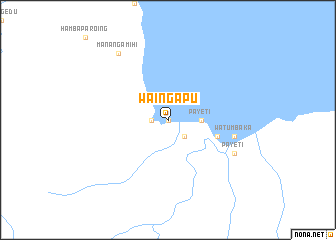
Nearby towns ::
Kampung Bugis (0.0km north) //
Kampung Sabu (0.0km north) //
Kampung Ende (0.0km north) //
Ndangu (1.8km west) //
Matawai (2.6km south east) //
Kambaniru (3.7km east) //
Payeti (3.7km east) //
Kawangu (5.8km east) //
Watumbaka (7.5km east) //
Payeti (8.2km south east) //
Manangamihi (9.2km north west) //
[all distances 'as the bird flies' and approximate] 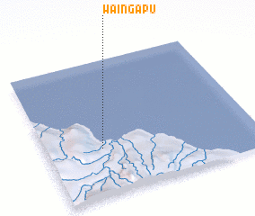 Places with similar names to Waingapu, Indonesia ::
// Hwangp'o (KR)
// Hwangp'o (KR)
// Hwangŏp'o (KP)
// Wān Hkai-pa-aw (MM)
// Wān Kawpa (MM)
// Winougap (VU)
// Wān Hkawp (MM)
// Wān Kao-paw (MM)
// Wān Kāp (MM)
// Wankapaw (MM)
Disclaimer :: Information on this page comes without warranty of any kind |
||
|
Where is Waingapu? Elevation and coordinates ::
Latitude (lat): 9°39'0"S Longitude (lon): 120°16'0"E
Elevation (approx.): 12m (map arrows pan, magnifying glasses zoom) |
||
|
Visiting Waingapu? Hotel/Accommodation ::
Book a hotel in Waingapu Travel Guide ::
Buy a travel guide for Indonesia rental cars ::
car rental offers GPS waypoint ::
download a GPX waypoint (PoI) of Waingapu for your GPS receiver
|
||