|
search place name
|
||
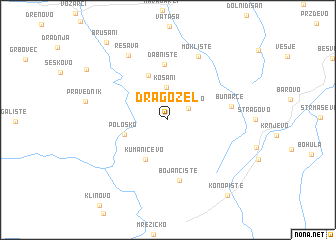
Dragožel (Macedonia, The Republic of)Dragožel is a town in Macedonia, The Republic of. An overview map of the region around Dragožel is displayed below.
regional and 3d topo map of Dragožel, Macedonia, The Republic of ::
Dragožel airports ::
The nearest airport is SKP - Skopje, located 78.2 km north west of Dragožel.
Other airports nearby include OHD - Ohrid (108.0 km west), KSO - Kastoria Aristotelis (115.4 km south west), KZI - Kozani Filippos (116.1 km south), SKG - Thessaloniki Makedonia (120.1 km south east), Nearby towns ::
Garnikovo (2.2km north east) //
Košani (3.7km north) //
Kumaničevo (4.8km south west) //
(( Pološko )) (4.0km south west) //
Begnište (5.2km north) //
Dabnište (6.2km north) //
Bojančište (6.8km south) //
Bunarče (5.6km east) //
Moklište (7.5km north) //
Resava (7.9km north west) //
Konopište (9.8km south east) //
Brušani (10.1km north west) //
[all distances 'as the bird flies' and approximate]  Places with similar names to Dragožel, Macedonia, The Republic of ::
// Tarkasale (RU)
// Tarko-Sale (RU)
// Drexel (US)
// Troxel (US)
// Ytre Okslia (NO)
// Drogosław (PL)
// Drogosław (PL)
// Drogosław (PL)
// Tirkšliai (LT)
// Trakšeliai (LT)
Disclaimer :: Information on this page comes without warranty of any kind |
||
|
Where is Dragožel? Elevation and coordinates ::
Latitude (lat): 41°19'23"N Longitude (lon): 22°1'2"E
Elevation (approx.): 620m (map arrows pan, magnifying glasses zoom) |
||
|
Visiting Dragožel? Hotel/Accommodation ::
Book a hotel in Dragožel Travel Guide ::
rental cars ::
car rental offers GPS waypoint ::
download a GPX waypoint (PoI) of Dragožel for your GPS receiver
|
||