|
search place name
|
||
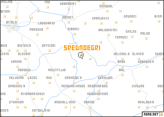
Sredno Egri (Macedonia, The Republic of)Sredno Egri is a town in Macedonia, The Republic of. An overview map of the region around Sredno Egri is displayed below.
regional and 3d topo map of Sredno Egri, Macedonia, The Republic of ::
Sredno Egri airports ::
The nearest airport is KSO - Kastoria Aristotelis, located 60.2 km south of Sredno Egri.
Other airports nearby include OHD - Ohrid (66.6 km west), KZI - Kozani Filippos (81.4 km south), SKP - Skopje (111.1 km north), SKG - Thessaloniki Makedonia (135.1 km east), Nearby towns ::
Gneotino (1.9km north) //
Dolno Egri (1.4km east) //
Gorno Egri (2.3km south west) //
Novo Selo (4.9km north east) //
Kremenica (5.7km south) //
Ribarci (5.8km north) //
Medžitlija (5.6km south west) //
Optičari (5.9km west) //
Néos Kávkasos (7.5km south) //
Germijan (7.0km south east) //
Biljanik (8.1km north) //
Baldovenci (7.2km north east) //
Mesókambos (7.9km south) //
Novaci (8.7km north) //
Vranjevci (8.8km north) //
Níki (7.9km south west) //
Logovardi (9.3km north west) //
Paralovo (10.2km north east) //
[all distances 'as the bird flies' and approximate]  Places with similar names to Sredno Egri, Macedonia, The Republic of ::
// Siradiankoro (ML)
// (( Srednogorie )) (BG)
Disclaimer :: Information on this page comes without warranty of any kind |
||
|
Where is Sredno Egri? Elevation and coordinates ::
Latitude (lat): 40°58'0"N Longitude (lon): 21°29'0"E
Elevation (approx.): 575m (map arrows pan, magnifying glasses zoom) |
||
|
Visiting Sredno Egri? Hotel/Accommodation ::
Book a hotel in Sredno Egri Travel Guide ::
rental cars ::
car rental offers GPS waypoint ::
download a GPX waypoint (PoI) of Sredno Egri for your GPS receiver
|
||