|
search place name
|
||
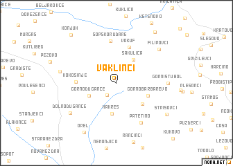
Vaklinci (Macedonia, The Republic of)Vaklinci is a town in Macedonia, The Republic of. An overview map of the region around Vaklinci is displayed below.
regional and 3d topo map of Vaklinci, Macedonia, The Republic of ::
Vaklinci airports ::
The nearest airport is SKP - Skopje, located 33.9 km west of Vaklinci.
Other airports nearby include PRN - Pristina (102.6 km north west), SOF - Sofia (136.8 km north east), OHD - Ohrid (141.3 km south west), INI - Nis (147.9 km north), Nearby towns ::
Stroimanci (2.3km south west) //
Tatomir (3.3km north west) //
Sakulica (4.2km north east) //
Gorno Ðugance (3.9km south west) //
Makreš (5.0km south) //
Dolno Barbarevo (4.6km south east) //
Gorno Barbarevo (4.3km south east) //
Vakuf (5.9km north) //
Kokošinje (4.8km west) //
Šopsko Rudare (6.8km north) //
Patetino (7.1km south east) //
Gorni Stubol (6.2km east) //
Filipovci (7.4km north east) //
Dolno Ðugance (7.4km south west) //
Strisovci (7.9km south east) //
Orel (8.9km south west) //
Topolovik (9.4km north east) //
Konjuh (9.4km north west) //
[all distances 'as the bird flies' and approximate] 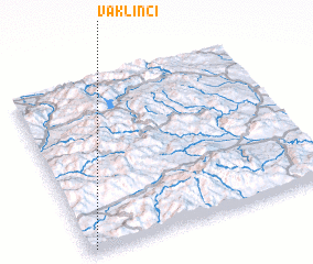 Places with similar names to Vaklinci, Macedonia, The Republic of ::
Disclaimer :: Information on this page comes without warranty of any kind |
||
|
Where is Vaklinci? Elevation and coordinates ::
Latitude (lat): 42°0'43"N Longitude (lon): 22°1'30"E
Elevation (approx.): 691m (map arrows pan, magnifying glasses zoom) |
||
|
Visiting Vaklinci? Hotel/Accommodation ::
Book a hotel in Vaklinci Travel Guide ::
rental cars ::
car rental offers GPS waypoint ::
download a GPX waypoint (PoI) of Vaklinci for your GPS receiver
|
||