|
search place name
|
||
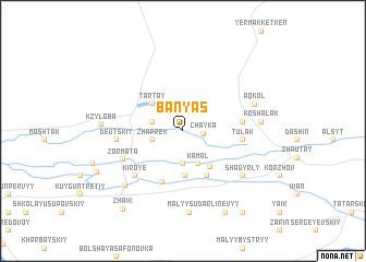
Banʼyas (Atyraū, Kazakhstan)Banʼyas is a town in the Atyraū region of Kazakhstan. An overview map of the region around Banʼyas is displayed below.
regional and 3d topo map of Banʼyas, Kazakhstan ::
Banʼyas airports ::
The nearest airport is ASF - Astrakhan, located 82.6 km south west of Banʼyas.
Nearby towns ::
Chayka (1.5km east) //
(( Dimbay )) (2.3km north west) //
(( Zhaprek )) (2.3km south west) //
Borsk (3.4km south) //
Kamal (3.6km south) //
(( Tartay )) (3.5km north west) //
Dolgun (4.5km south) //
Pervoye Maya (4.2km south east) //
(( Sennoy )) (4.9km south) //
Talambay (5.5km south) //
Tulak (4.3km east) //
Kishkin-Aral (4.3km east) //
(( Kiroye )) (5.7km south west) //
Zormata (5.1km south west) //
(( Deutskiy )) (4.8km west) //
Shagyrly (6.3km south east) //
Aqköl (5.7km north east) //
Koshalak (5.6km east) //
Isembay (5.6km east) //
Irmen (6.9km south west) //
Kzyloba (5.8km west) //
(( Malyy Sudarʼ )) (8.4km south) //
(( Linëvyy )) (8.9km south) //
Kirse (7.4km south west) //
Zhaik (9.1km south west) //
Kobaniy (9.4km south east) //
[all distances 'as the bird flies' and approximate]  Places with similar names to Banʼyas, Kazakhstan ::
// Ban Yae So (TH)
// Ban Yi Sae (TH)
// Banāyūs (EG)
// Baniyaz (RU)
// Bāniyās (SY)
// Bāniyās (SY)
// Benayes (FR)
// Boneh-ye ‘Īsá (IR)
// Banī Yūs (YE)
Disclaimer :: Information on this page comes without warranty of any kind |
||
|
Where is Banʼyas? Elevation and coordinates ::
Latitude (lat): 46°37'30"N Longitude (lon): 48°57'40"E
Elevation (approx.): -27m (map arrows pan, magnifying glasses zoom) |
||
|
Visiting Banʼyas? Hotel/Accommodation ::
Book a hotel in Banʼyas Travel Guide ::
Buy a travel guide for Kazakhstan rental cars ::
car rental offers GPS waypoint ::
download a GPX waypoint (PoI) of Banʼyas for your GPS receiver
|
||