|
search place name
|
||
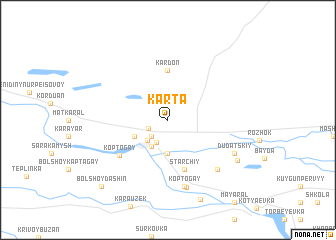
(( Karta )) (Atyraū, Kazakhstan)(( Karta )) is a town in the Atyraū region of Kazakhstan. An overview map of the region around (( Karta )) is displayed below.
regional and 3d topo map of (( Karta )), Kazakhstan ::
(( Karta )) airports ::
The nearest airport is ASF - Astrakhan, located 63.9 km south west of (( Karta )).
Nearby towns ::
Zhylandy (1.8km south west) //
(( Kaptagay )) (2.2km south west) //
Shortanbay (2.7km south) //
Lʼdobaza (2.8km south west) //
Rembaza (3.2km south west) //
(( Armbiryuk )) (3.7km south) //
(( Shestoy )) (3.7km south) //
(( Kamstaral )) (3.7km south) //
(( Koreyskiy )) (3.1km south west) //
Kardon (5.6km north) //
(( Starchiy )) (5.7km south) //
Koptogay (5.4km south west) //
(( Dolonka )) (7.5km south) //
(( Koptogay )) (7.5km south) //
Gangyushkīno (7.7km south) //
(( Alʼmanbyuruk )) (6.7km south east) //
(( Dudatskiy )) (6.3km south east) //
Arynbyurek (7.0km south east) //
(( Bolʼshoy Dashin )) (9.0km south west) //
[all distances 'as the bird flies' and approximate]  Places with similar names to (( Karta )), Kazakhstan ::
Disclaimer :: Information on this page comes without warranty of any kind |
||
|
Where is (( Karta ))? Elevation and coordinates ::
Latitude (lat): 46°38'0"N Longitude (lon): 48°40'0"E
Elevation (approx.): -28m (map arrows pan, magnifying glasses zoom) |
||
|
Visiting (( Karta ))? Hotel/Accommodation ::
Book a hotel in (( Karta )) Travel Guide ::
Buy a travel guide for Kazakhstan rental cars ::
car rental offers GPS waypoint ::
download a GPX waypoint (PoI) of (( Karta )) for your GPS receiver
|
||