|
search place name
|
||
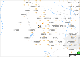
Nderi (Central, Kenya)Nderi is a town in the Central region of Kenya. An overview map of the region around Nderi is displayed below.
regional and 3d topo map of Nderi, Kenya ::
Nderi airports ::
The nearest airport is WIL - Nairobi Wilson, located 21.7 km south east of Nderi.
Other airports nearby include EDL - Eldoret Intl (238.3 km north west), KIS - Kisumu (247.7 km north west), Nearby towns ::
Kiambaa (1.9km north) //
Kamuguga (1.9km east) //
Gatiabai (2.6km south east) //
Gatuanibu (2.6km north east) //
Ngoriundito (2.6km north west) //
Kahuho (3.7km east) //
Gathithina (3.7km east) //
Muguga (3.7km north) //
Renguti (4.1km south west) //
Ngure (4.1km south east) //
Rungiri (4.1km south east) //
Gitaru (4.1km south east) //
Kikuyu (4.1km south east) //
Kajinga (4.1km north east) //
Kaimba (4.1km north east) //
Kabochu (5.2km north east) //
Gicharani (5.6km south) //
Gatimu (5.6km north) //
Mahinga (5.6km north) //
Chura (5.6km east) //
Ndurarua (5.9km east) //
Rukubi (5.9km east) //
Kanyariri (5.9km east) //
Sigio (5.9km west) //
Thigio (5.9km west) //
Kiroe (5.9km west) //
Thogoto (5.9km south) //
Ngecha (5.9km north) //
Gichuru (5.9km north) //
[all distances 'as the bird flies' and approximate]  Places with similar names to Nderi, Kenya ::
Disclaimer :: Information on this page comes without warranty of any kind |
||
|
Where is Nderi? Elevation and coordinates ::
Latitude (lat): 1°13'0"S Longitude (lon): 36°39'0"E
Elevation (approx.): 2095m (map arrows pan, magnifying glasses zoom) |
||
|
Visiting Nderi? Hotel/Accommodation ::
Book a hotel in Nderi Travel Guide ::
Buy a travel guide for Kenya rental cars ::
car rental offers GPS waypoint ::
download a GPX waypoint (PoI) of Nderi for your GPS receiver
|
||