|
search place name
|
||
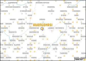
Adangomasi (Ghana)Adangomasi is a town in Ghana. An overview map of the region around Adangomasi is displayed below.
regional and 3d topo map of Adangomasi, Ghana ::
Adangomasi airports ::
The nearest airport is NYI - Sunyani, located 112.7 km north west of Adangomasi.
Other airports nearby include ACC - Accra Kotoka Intl (196.6 km south east), TKD - Takoradi (215.1 km south), Nearby towns ::
Amanpe (1.9km south) //
Safo (2.6km north west) //
Dumakwai (3.7km north) //
Kasaim (3.7km north) //
Asonomaso (3.7km west) //
Bonweri (3.7km south) //
Juaben (3.7km east) //
Sakra Wono (4.1km south west) //
Bamang (4.1km south east) //
Ebira (5.9km south) //
Ntonso (5.8km west) //
Krobo (6.7km south west) //
Ahunjo (6.6km south west) //
Patapong (7.4km east) //
Aboabo Nkwanta (7.6km west) //
Abankrom (7.6km south) //
Asuchwi (7.6km south) //
Adeusina (7.8km south west) //
Kona (7.8km north west) //
Nantang (8.2km north west) //
Brofoyedru (8.3km north west) //
Ajumakese (8.2km south west) //
Obuohu (8.3km north east) //
Adense (8.3km south west) //
Efiduasi (8.2km north east) //
Asenyebun (9.2km north west) //
Apemso (9.2km south east) //
Antoa (9.2km south west) //
Nsutem (9.2km north east) //
[all distances 'as the bird flies' and approximate]  Places with similar names to Adangomasi, Ghana :: Disclaimer :: Information on this page comes without warranty of any kind |
||
|
Where is Adangomasi? Elevation and coordinates ::
Latitude (lat): 6°49'0"N Longitude (lon): 1°28'0"W
Elevation (approx.): 299m (map arrows pan, magnifying glasses zoom) |
||
|
Visiting Adangomasi? Hotel/Accommodation ::
Book a hotel in Adangomasi Travel Guide ::
Buy a travel guide for Ghana rental cars ::
car rental offers GPS waypoint ::
download a GPX waypoint (PoI) of Adangomasi for your GPS receiver
|
||