|
search place name
|
||
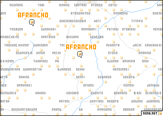
Afrancho (Ghana)Afrancho is a town in Ghana. An overview map of the region around Afrancho is displayed below.
regional and 3d topo map of Afrancho, Ghana ::
Afrancho airports ::
The nearest airport is NYI - Sunyani, located 118.2 km north west of Afrancho.
Other airports nearby include TKD - Takoradi (183.6 km south), ACC - Accra Kotoka Intl (193.1 km south east), Nearby towns ::
Konkori (1.8km west) //
Kwanwuma (1.9km north) //
Twinuasi (1.9km south) //
Sehwi (3.7km south) //
Bekwami (4.1km north west) //
Dominasi (4.1km south west) //
Trede (4.1km north west) //
Dedesua (5.2km north east) //
Ajamaso (5.2km south west) //
Pechi (5.5km west) //
Senfi (5.6km south) //
Old Pechi (5.5km west) //
Eduadin (5.5km east) //
Ampabami (5.9km north) //
Pa (5.8km west) //
Oyoko (7.4km east) //
Nkwanta (7.6km east) //
Ajumam (7.6km east) //
Adunku (7.6km east) //
Sokoben (7.6km north) //
Ofuasi (7.6km south) //
Oheneba Kokobin (7.6km north) //
Samanhia (7.6km west) //
Ampabami (7.8km north west) //
Edumasa (7.8km south east) //
Abuontem (8.2km north east) //
Mpatasie (8.2km north west) //
Woti (8.3km north east) //
Brofoyedru (8.3km north west) //
[all distances 'as the bird flies' and approximate]  Places with similar names to Afrancho, Ghana ::
// Afrancho (GH)
Disclaimer :: Information on this page comes without warranty of any kind |
||
|
Where is Afrancho? Elevation and coordinates ::
Latitude (lat): 6°33'0"N Longitude (lon): 1°38'0"W
Elevation (approx.): 238m (map arrows pan, magnifying glasses zoom) |
||
|
Visiting Afrancho? Hotel/Accommodation ::
Book a hotel in Afrancho Travel Guide ::
Buy a travel guide for Ghana rental cars ::
car rental offers GPS waypoint ::
download a GPX waypoint (PoI) of Afrancho for your GPS receiver
|
||