|
search place name
|
||
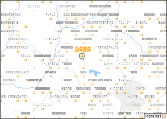
Daba (Ghana)Daba is a town in Ghana. An overview map of the region around Daba is displayed below.
regional and 3d topo map of Daba, Ghana ::
Daba airports ::
The nearest airport is NYI - Sunyani, located 94.4 km north west of Daba.
Other airports nearby include TKD - Takoradi (207.0 km south), ACC - Accra Kotoka Intl (214.3 km south east), Nearby towns ::
Esaso (1.9km north) //
Owabi (1.9km south) //
Kapro (2.6km north west) //
Adankwamu (3.7km north) //
Akwaboa (3.7km west) //
Sasi (3.7km south) //
Asuofia (3.7km east) //
Pasaro (4.1km north west) //
Tabiri (4.1km south west) //
Kokobin (4.1km south west) //
Achiasi (4.1km north east) //
Akropong (4.1km south west) //
Aninkroma (5.2km north west) //
Menhia (5.6km south) //
Sukwai (5.5km west) //
Hemang (5.5km east) //
Mabai (5.9km north) //
Ajeikrom (5.8km west) //
Ntri Boahung (5.8km east) //
Kokobin (5.9km north) //
Bokanchi (5.9km south) //
Ntinsiri (5.8km west) //
Owhim (5.8km east) //
Tabiri (6.7km south west) //
Nyanchreniasi (6.7km south east) //
Asuminya (7.4km north) //
Mfensi (7.4km west) //
Abuakwa (7.4km south) //
Asrimaso (7.4km south) //
[all distances 'as the bird flies' and approximate]  Places with similar names to Daba, Ghana ::
Disclaimer :: Information on this page comes without warranty of any kind |
||
|
Where is Daba? Elevation and coordinates ::
Latitude (lat): 6°46'0"N Longitude (lon): 1°43'0"W
Elevation (approx.): 232m (map arrows pan, magnifying glasses zoom) |
||
|
Visiting Daba? Hotel/Accommodation ::
Book a hotel in Daba Travel Guide ::
Buy a travel guide for Ghana rental cars ::
car rental offers GPS waypoint ::
download a GPX waypoint (PoI) of Daba for your GPS receiver
|
||