|
search place name
|
||
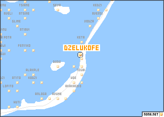
Dzelukofe (Ghana)Dzelukofe is a town in Ghana. An overview map of the region around Dzelukofe is displayed below.
regional and 3d topo map of Dzelukofe, Ghana ::
Dzelukofe airports ::
The nearest airport is LFW - Lome Gnassingbe Eyadema Intl, located 43.3 km north east of Dzelukofe.
Other airports nearby include ACC - Accra Kotoka Intl (131.1 km west), COO - Cotonou Cadjehoun (163.7 km east), Nearby towns ::
Tetekofe (0.0km north) //
Dzrokofe (0.0km north) //
Vui (0.0km north) //
Kpovikofe (1.9km south) //
Agbodrafo (1.9km south) //
Agbenuvokofe (1.9km south) //
Jiniagba (1.9km south) //
Zedevu (2.6km south west) //
Tegbi (3.7km south) //
Kpotafuta (3.7km south) //
Keta (3.7km north) //
Tsinyokofe (5.6km south) //
Hedeglokofe (5.6km south) //
Antoniokofe (5.6km south) //
Dudu (5.8km west) //
Woe (5.9km south) //
Akakagbo (7.6km south) //
Vodza (7.6km north) //
[all distances 'as the bird flies' and approximate] 
Disclaimer :: Information on this page comes without warranty of any kind |
||
|
Where is Dzelukofe? Elevation and coordinates ::
Latitude (lat): 5°53'0"N Longitude (lon): 0°59'0"W
Elevation (approx.): 4m (map arrows pan, magnifying glasses zoom) |
||
|
Visiting Dzelukofe? Hotel/Accommodation ::
Book a hotel in Dzelukofe Travel Guide ::
Buy a travel guide for Ghana rental cars ::
car rental offers GPS waypoint ::
download a GPX waypoint (PoI) of Dzelukofe for your GPS receiver
|
||