|
search place name
|
||
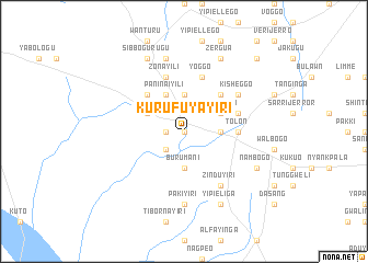
Kurufuyayiri (Ghana)Kurufuyayiri is a town in Ghana. An overview map of the region around Kurufuyayiri is displayed below.
regional and 3d topo map of Kurufuyayiri, Ghana ::
Kurufuyayiri airports ::
The nearest airport is TML - Tamale, located 31.0 km north east of Kurufuyayiri.
Nearby towns ::
Tale (0.0km north) //
Dulnayinga (1.8km west) //
Tiboggo (2.6km south west) //
Burumani (3.7km south) //
Noori (3.7km east) //
Bambea (3.7km north) //
Kumahayiri (4.1km north west) //
Paninaiyili (4.1km north west) //
Yoboaiyili (4.1km north east) //
Jaragolili (5.2km north west) //
Fieniti (5.2km north east) //
Tolon (5.5km east) //
Yirong (5.9km north) //
Zonayili (5.9km north) //
Sabia (5.8km east) //
Yoggo (5.9km north) //
Zinduyiri (6.7km south east) //
Kisheggo (6.6km north east) //
Pakiyiri (7.4km south) //
Kumenayili (7.6km north) //
Yipieliga (8.3km south east) //
Nambogo (8.2km south east) //
Sibbogurugu (8.3km north west) //
Zergua (8.3km north east) //
Bimbirooili (10.4km north east) //
[all distances 'as the bird flies' and approximate]  Places with similar names to Kurufuyayiri, Ghana :: Disclaimer :: Information on this page comes without warranty of any kind |
||
|
Where is Kurufuyayiri? Elevation and coordinates ::
Latitude (lat): 9°26'0"N Longitude (lon): 1°7'0"W
Elevation (approx.): 133m (map arrows pan, magnifying glasses zoom) |
||
|
Visiting Kurufuyayiri? Hotel/Accommodation ::
Book a hotel in Kurufuyayiri Travel Guide ::
Buy a travel guide for Ghana rental cars ::
car rental offers GPS waypoint ::
download a GPX waypoint (PoI) of Kurufuyayiri for your GPS receiver
|
||