|
search place name
|
||
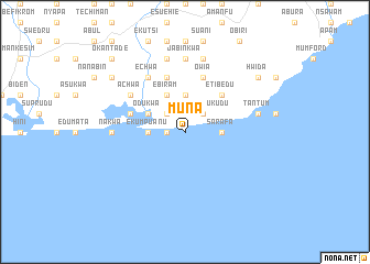
Muna (Ghana)Muna is a town in Ghana. An overview map of the region around Muna is displayed below.
regional and 3d topo map of Muna, Ghana ::
Muna airports ::
The nearest airport is ACC - Accra Kotoka Intl, located 89.6 km north east of Muna.
Other airports nearby include TKD - Takoradi (106.2 km west), Nearby towns ::
Akra (1.8km west) //
Mbroboto (2.6km north west) //
Sarafa Kukudu (2.6km north east) //
Awofa (3.7km north) //
Ekumpuanu (3.7km west) //
Sarafa (3.7km east) //
Aboano (3.7km east) //
Ebiram (4.1km north west) //
Ebiramkrom (4.1km north west) //
Odukwa (4.1km north west) //
Kwaprakwa (4.1km north west) //
Etibedu (5.2km north east) //
Adansemem (5.9km north) //
Owia (5.9km north) //
Einado (5.8km west) //
Abuakwa (6.7km north west) //
Achwa (6.7km north west) //
Echwa (6.7km north west) //
Atsuakrom (6.7km north west) //
Nakwa (7.4km west) //
Jabinkwa (7.4km north) //
Adansi (7.6km north) //
Ejaku Kwa (7.6km north) //
Tantum (7.6km east) //
Bojwanu (9.2km north west) //
Hwida (9.2km north east) //
Okantade (10.5km north west) //
[all distances 'as the bird flies' and approximate]  Places with similar names to Muna, Ghana ::
Disclaimer :: Information on this page comes without warranty of any kind |
||
|
Where is Muna? Elevation and coordinates ::
Latitude (lat): 5°12'0"N Longitude (lon): 0°52'0"W
Elevation (approx.): -32768m (map arrows pan, magnifying glasses zoom) |
||
|
Visiting Muna? Hotel/Accommodation ::
Book a hotel in Muna Travel Guide ::
Buy a travel guide for Ghana rental cars ::
car rental offers GPS waypoint ::
download a GPX waypoint (PoI) of Muna for your GPS receiver
|
||