|
search place name
|
||
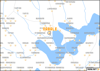
Nabale (Ghana)Nabale is a town in Ghana. An overview map of the region around Nabale is displayed below.
regional and 3d topo map of Nabale, Ghana ::
Nabale airports ::
The nearest airport is LRL - Niatougou Niamtougou International, located 129.2 km south east of Nabale.
Other airports nearby include TML - Tamale (140.9 km south west), OUA - Ouagadougou (278.7 km north west), Nearby towns ::
Kinkongo (1.9km north) //
Bungbonkurugu (2.6km south west) //
Nyambande (2.6km north west) //
Bongpulugu (3.7km north) //
Nyambande (3.6km west) //
Nanbali (3.7km south) //
Tuobongo (4.1km north west) //
Deboni (4.1km north east) //
Chagbanga (4.1km north west) //
Bumbuna (6.6km north west) //
Naziago (6.6km south west) //
Kpebongo (6.6km south east) //
Biambigi (7.5km east) //
Wuragbane (7.5km east) //
Kungkungbonge (7.8km north east) //
Suoko (7.8km south west) //
Wagagu (8.2km north east) //
Tuobongo (8.3km south east) //
Diapa (9.2km north east) //
Jengendere (9.2km south west) //
Kpumboie (9.2km south west) //
Tambona (9.2km south west) //
Kpalamboni (9.2km south west) //
Tojenda (10.4km south east) //
[all distances 'as the bird flies' and approximate] 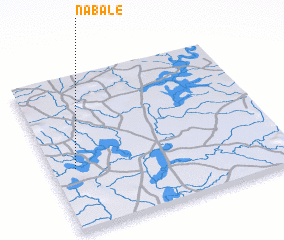 Places with similar names to Nabale, Ghana ::
Disclaimer :: Information on this page comes without warranty of any kind |
||
|
Where is Nabale? Elevation and coordinates ::
Latitude (lat): 10°24'0"N Longitude (lon): 0°6'0"W
Elevation (approx.): 146m (map arrows pan, magnifying glasses zoom) |
||
|
Visiting Nabale? Hotel/Accommodation ::
Book a hotel in Nabale Travel Guide ::
Buy a travel guide for Ghana rental cars ::
car rental offers GPS waypoint ::
download a GPX waypoint (PoI) of Nabale for your GPS receiver
|
||