|
search place name
|
||
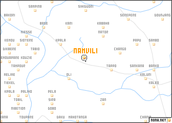
Namvili (Ghana)Namvili is a town in Ghana. An overview map of the region around Namvili is displayed below.
regional and 3d topo map of Namvili, Ghana ::
Namvili airports ::
The nearest airport is BOY - Bobo-dioulasso Bobo Dioulasso, located 208.3 km north west of Namvili.
Other airports nearby include TML - Tamale (212.5 km east), Nearby towns ::
Oli (5.2km south west) //
Gili (5.8km east) //
Tappo (5.8km east) //
Kpala (6.6km north west) //
Nator (6.6km north east) //
Chango (7.5km east) //
Kabaha (8.3km north east) //
Kari (8.3km north west) //
Murathu (10.4km south west) //
Pela (10.4km south west) //
[all distances 'as the bird flies' and approximate] 
Disclaimer :: Information on this page comes without warranty of any kind |
||
|
Where is Namvili? Elevation and coordinates ::
Latitude (lat): 10°13'0"N Longitude (lon): 2°41'0"W
Elevation (approx.): 283m (map arrows pan, magnifying glasses zoom) |
||
|
Visiting Namvili? Hotel/Accommodation ::
Book a hotel in Namvili Travel Guide ::
Buy a travel guide for Ghana rental cars ::
car rental offers GPS waypoint ::
download a GPX waypoint (PoI) of Namvili for your GPS receiver
|
||