|
search place name
|
||
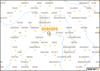
Okakope (Ghana)Okakope is a town in Ghana. An overview map of the region around Okakope is displayed below.
regional and 3d topo map of Okakope, Ghana ::
Okakope airports ::
The nearest airport is LFW - Lome Gnassingbe Eyadema Intl, located 97.0 km south east of Okakope.
Other airports nearby include ACC - Accra Kotoka Intl (152.4 km south west), COO - Cotonou Cadjehoun (202.1 km east), Nearby towns ::
Nyive (0.0km north) //
Nyivé (2.6km north west) //
Kalakala (3.7km north) //
Akpakope (3.7km south) //
Atikpui (3.7km east) //
Youssakofé (4.1km north west) //
Bayime (4.1km south west) //
Zomai (4.1km south east) //
Nachive (4.1km south west) //
Shia (5.2km north west) //
Kpoyikofé (5.9km north) //
Gbogame (5.8km west) //
Tokokoe (6.7km south west) //
Agripakopé (6.7km north east) //
Komiyaokofe (6.7km north west) //
Agoukpoéta (6.7km north east) //
Tsétsé Kopé (6.7km south east) //
Wotokou (7.4km east) //
Hodzoga (7.6km south) //
Yéviéfé (7.6km north) //
Aviepe (7.6km south) //
Totoyi (7.6km south) //
Kavou (7.6km north) //
Adamé (7.6km east) //
Odomiabra (7.8km south west) //
Kokou Kopé (7.8km south east) //
Devime (7.8km south east) //
Klukofe (8.3km north west) //
Bolomegblé (8.3km north east) //
[all distances 'as the bird flies' and approximate] 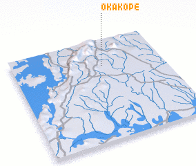 Places with similar names to Okakope, Ghana :: Disclaimer :: Information on this page comes without warranty of any kind |
||
|
Where is Okakope? Elevation and coordinates ::
Latitude (lat): 6°45'0"N Longitude (lon): 0°36'0"W
Elevation (approx.): 148m (map arrows pan, magnifying glasses zoom) |
||
|
Visiting Okakope? Hotel/Accommodation ::
Book a hotel in Okakope Travel Guide ::
Buy a travel guide for Ghana rental cars ::
car rental offers GPS waypoint ::
download a GPX waypoint (PoI) of Okakope for your GPS receiver
|
||