|
search place name
|
||
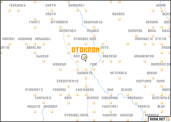
Otokrom (Ghana)Otokrom is a town in Ghana. An overview map of the region around Otokrom is displayed below.
regional and 3d topo map of Otokrom, Ghana ::
Otokrom airports ::
The nearest airport is TKD - Takoradi, located 97.5 km south west of Otokrom.
Other airports nearby include ACC - Accra Kotoka Intl (111.1 km east), NYI - Sunyani (239.6 km north west), Nearby towns ::
Manso (1.9km south) //
Ano (1.8km west) //
Chinso (2.6km south west) //
Tebi (2.6km south east) //
Adenchi (2.6km south east) //
Bisiasi (2.6km north west) //
Kwamiata (3.7km south) //
Odumasi (3.7km east) //
Nyamibechire (3.7km north) //
Dadieso (4.1km north west) //
Tehinite (4.1km north east) //
Damawaku (5.2km north west) //
Mahamiti (5.2km north east) //
Achiasi (5.6km south) //
Aberesa (5.5km east) //
Hiaheda (5.8km west) //
Krochuano (5.9km north) //
Nkuben (5.9km north) //
Akrofuom (6.7km north west) //
Ensonyamiye (6.7km south west) //
Chichiwere (7.4km south) //
Anyinaso (7.4km east) //
Asuboa (7.6km south) //
Odumkwaku (7.6km north) //
Amuakromakrofo (8.3km south west) //
Metemanu (8.3km south east) //
Framasi (9.3km south west) //
Oda (9.3km south east) //
Aiyinabrim (9.3km north west) //
[all distances 'as the bird flies' and approximate] 
Disclaimer :: Information on this page comes without warranty of any kind |
||
|
Where is Otokrom? Elevation and coordinates ::
Latitude (lat): 5°32'0"N Longitude (lon): 1°10'0"W
Elevation (approx.): 106m (map arrows pan, magnifying glasses zoom) |
||
|
Visiting Otokrom? Hotel/Accommodation ::
Book a hotel in Otokrom Travel Guide ::
Buy a travel guide for Ghana rental cars ::
car rental offers GPS waypoint ::
download a GPX waypoint (PoI) of Otokrom for your GPS receiver
|
||