|
search place name
|
||
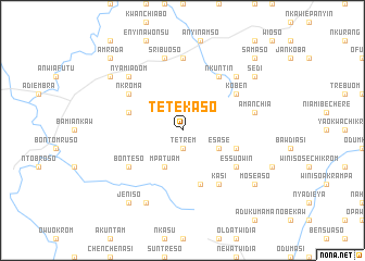
Tetekaso (Ghana)Tetekaso is a town in Ghana. An overview map of the region around Tetekaso is displayed below.
regional and 3d topo map of Tetekaso, Ghana ::
Tetekaso airports ::
The nearest airport is NYI - Sunyani, located 99.0 km north west of Tetekaso.
Other airports nearby include TKD - Takoradi (185.4 km south), ACC - Accra Kotoka Intl (221.0 km south east), Nearby towns ::
Tetrem (1.9km south) //
Mpatuam (4.1km south west) //
Esase (4.1km south east) //
Kojwirakrom (5.8km west) //
Asuokaw Aboi (5.9km south) //
Ahwiriwa (5.8km east) //
Koben (6.7km north east) //
Asuoja (6.7km north east) //
Nkroma (6.7km north west) //
Kasi (6.7km south east) //
Nkuntin (6.7km north east) //
Essuowin (6.7km south east) //
Bonteso (6.7km south west) //
Afawtawkaw (7.4km north) //
Sribuoso (7.6km north) //
Amanchia (7.6km east) //
Nyamiadom (7.8km north west) //
Ajumam (7.8km north west) //
Mahami (7.8km north east) //
Akantaniasi (8.3km south west) //
Nkroma (9.2km north west) //
Moseaso (9.2km south east) //
Sedi (9.2km north east) //
Jeniso (9.2km south west) //
Amrada (10.4km north west) //
Samaso (10.4km north east) //
[all distances 'as the bird flies' and approximate]  Places with similar names to Tetekaso, Ghana ::
Disclaimer :: Information on this page comes without warranty of any kind |
||
|
Where is Tetekaso? Elevation and coordinates ::
Latitude (lat): 6°34'0"N Longitude (lon): 1°55'0"W
Elevation (approx.): 275m (map arrows pan, magnifying glasses zoom) |
||
|
Visiting Tetekaso? Hotel/Accommodation ::
Book a hotel in Tetekaso Travel Guide ::
Buy a travel guide for Ghana rental cars ::
car rental offers GPS waypoint ::
download a GPX waypoint (PoI) of Tetekaso for your GPS receiver
|
||