|
search place name
|
||
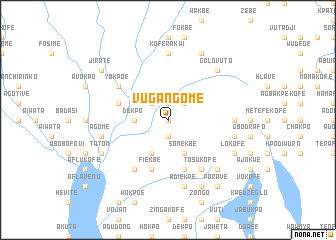
Vugangome (Ghana)Vugangome is a town in Ghana. An overview map of the region around Vugangome is displayed below.
regional and 3d topo map of Vugangome, Ghana ::
Vugangome airports ::
The nearest airport is LFW - Lome Gnassingbe Eyadema Intl, located 86.6 km east of Vugangome.
Other airports nearby include ACC - Accra Kotoka Intl (105.3 km south west), COO - Cotonou Cadjehoun (210.4 km east), Nearby towns ::
Achiafi (0.0km north) //
Achiafime (1.9km south) //
Sonukpo (1.9km north) //
Atihwi (2.6km north west) //
Agekpo (2.6km north east) //
Dekpo (3.7km west) //
Azavokofe (3.7km west) //
Adidokpoe (4.1km south west) //
Somekbe (4.1km south east) //
Fiekbe (5.9km south) //
Agoe (5.9km south) //
Latekofe (5.9km south) //
Kulasi (5.8km west) //
Bokpo (6.7km south west) //
Fialenyigban (6.7km south west) //
Yokpoe (6.7km north west) //
Tosukofe (6.7km south east) //
Koferakwi (7.4km north) //
Ahunda (7.4km east) //
Agome (7.6km west) //
Adiekpe (7.6km south) //
Boso (7.6km east) //
Golovuto (7.8km north east) //
Avuglanpu (7.8km south east) //
Taton (8.2km south west) //
Lokofe (8.2km south east) //
Dodjankpo (8.3km north east) //
Kpokofe (8.3km south east) //
Jirate (9.2km north west) //
[all distances 'as the bird flies' and approximate] 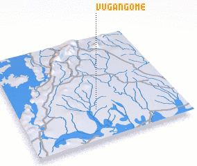 Places with similar names to Vugangome, Ghana :: Disclaimer :: Information on this page comes without warranty of any kind |
||
|
Where is Vugangome? Elevation and coordinates ::
Latitude (lat): 6°18'0"N Longitude (lon): 0°29'0"W
Elevation (approx.): 40m (map arrows pan, magnifying glasses zoom) |
||
|
Visiting Vugangome? Hotel/Accommodation ::
Book a hotel in Vugangome Travel Guide ::
Buy a travel guide for Ghana rental cars ::
car rental offers GPS waypoint ::
download a GPX waypoint (PoI) of Vugangome for your GPS receiver
|
||