|
search place name
|
||
Caramecuaro (Michoacán de Ocampo, Mexico)Caramecuaro is a town in the Michoacán de Ocampo region of Mexico. An overview map of the region around Caramecuaro is displayed below.
regional and 3d topo map of Caramecuaro, Mexico ::

Caramecuaro airports ::
The nearest airport is MLM - Morelia General Francisco J Mujica Intl, located 111.8 km north of Caramecuaro.
Other airports nearby include TLC - Toluca Licenciado Adolfo Lopez Mateos Intl (131.1 km north east), UPN - Uruapan Licenciado Y Gen Ignacio Lopez Rayon (150.3 km north west), CVJ - Cuernavaca General Mariano Matamoros (153.5 km east), ZIH - Ixtapa Zihuatanejo Intl (162.2 km south west), Nearby towns ::
Tiquicheo (1.8km west) //
El Paso de Cascalote (5.7km south) //
[all distances 'as the bird flies' and approximate] 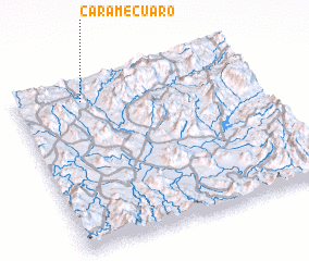 Places with similar names to Caramecuaro, Mexico ::
// Quirimbuquer (BR)
// Góry Mokre (PL)
// Grmčara (BA)
// Karamağara (TR)
// Karamağara (TR)
// Ga-Ramakara (ZA)
// Grumakroa (GH)
// Caramécuaro (MX)
// Keur Makar (SN)
// Kérémékoro (ML)
Disclaimer :: Information on this page comes without warranty of any kind |
||
|
Where is Caramecuaro? Elevation and coordinates ::
Latitude (lat): 18°53'0"N Longitude (lon): 100°43'0"W
Elevation (approx.): 452m (map arrows pan, magnifying glasses zoom) |
||
|
Visiting Caramecuaro? Hotel/Accommodation ::
Book a hotel in Caramecuaro Travel Guide ::
Buy a travel guide for Mexico rental cars ::
car rental offers GPS waypoint ::
download a GPX waypoint (PoI) of Caramecuaro for your GPS receiver
|
||