|
search place name
|
||
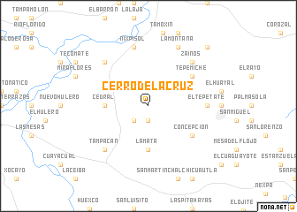
Cerro de la Cruz (San Luis Potosí, Mexico)Cerro de la Cruz is a town in the San Luis Potosí region of Mexico. An overview map of the region around Cerro de la Cruz is displayed below.
regional and 3d topo map of Cerro de la Cruz, Mexico ::
Cerro de la Cruz airports ::
The nearest airport is TSL - Tamuin, located 64.6 km north of Cerro de la Cruz.
Other airports nearby include TAM - Tampico General Francisco Javier Mina Intl (124.8 km north east), PCA - Pachuca Ingeniero Juan Guillermo Villasana (154.2 km south), PAZ - Poza Rico Tajin (159.1 km south east), QRO - Queretaro Intercontinental (182.3 km south west), Nearby towns ::
Los Cues (1.9km south) //
Víboras (2.5km south west) //
Bancos (2.5km south west) //
Cedral (5.2km west) //
La Mata (5.6km south) //
Tepemiche (6.4km north east) //
Concepción (6.4km south east) //
El Tepetate (6.9km east) //
Nixpisol (7.6km north) //
El Potosno (7.6km north) //
Zainos (7.6km north east) //
El Refugio (7.6km north west) //
El Terrero (7.6km north east) //
Tampacán (7.6km south west) //
La Montaña (8.2km north east) //
El Lindero (10.1km north east) //
[all distances 'as the bird flies' and approximate] 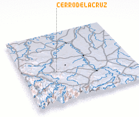 Places with similar names to Cerro de la Cruz, Mexico ::
Disclaimer :: Information on this page comes without warranty of any kind |
||
|
Where is Cerro de la Cruz? Elevation and coordinates ::
Latitude (lat): 21°28'0"N Longitude (lon): 98°41'0"W
Elevation (approx.): 172m (map arrows pan, magnifying glasses zoom) |
||
|
Visiting Cerro de la Cruz? Hotel/Accommodation ::
Book a hotel in Cerro de la Cruz Travel Guide ::
Buy a travel guide for Mexico rental cars ::
car rental offers GPS waypoint ::
download a GPX waypoint (PoI) of Cerro de la Cruz for your GPS receiver
|
||