|
search place name
|
||
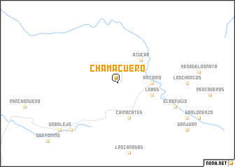
Chamacuero (Durango, Mexico)Chamacuero is a town in the Durango region of Mexico. An overview map of the region around Chamacuero is displayed below.
regional and 3d topo map of Chamacuero, Mexico ::
Chamacuero airports ::
The nearest airport is CUL - Culiacan Intl, located 152.8 km west of Chamacuero.
Other airports nearby include DGO - Durango Intl (192.3 km south east), Nearby towns ::
Azúcar (5.0km north east) //
Antonio (5.0km east) //
Lobos (5.4km east) //
Chinacates (5.8km south) //
Cueva del Negro (10.0km south west) //
[all distances 'as the bird flies' and approximate]  Places with similar names to Chamacuero, Mexico ::
// Shumaker (US)
// Cham Kareh (IR)
// Cham Kūr (IR)
// Shoemaker (US)
// Shoemaker (US)
// Shoemaker (US)
// Shāmkur (BD)
// Chāmkor (IN)
// Shāmgarh (IN)
// Chamacuero (MX)
Disclaimer :: Information on this page comes without warranty of any kind |
||
|
Where is Chamacuero? Elevation and coordinates ::
Latitude (lat): 25°11'0"N Longitude (lon): 106°2'0"W
Elevation (approx.): 2550m (map arrows pan, magnifying glasses zoom) |
||
|
Visiting Chamacuero? Hotel/Accommodation ::
Book a hotel in Chamacuero Travel Guide ::
Buy a travel guide for Mexico rental cars ::
car rental offers GPS waypoint ::
download a GPX waypoint (PoI) of Chamacuero for your GPS receiver
|
||