|
search place name
|
||
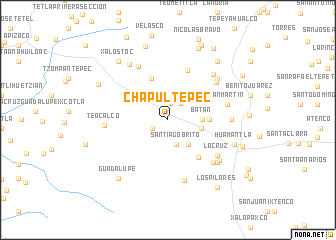
Chapultepec (Tlaxcala, Mexico)Chapultepec is a town in the Tlaxcala region of Mexico. An overview map of the region around Chapultepec is displayed below.
regional and 3d topo map of Chapultepec, Mexico ::
Chapultepec airports ::
The nearest airport is TXA - Tlaxcala, located 28.4 km north west of Chapultepec.
Other airports nearby include PBC - Puebla Hermanos Serdan Intl (44.0 km south west), TCN - Tehuacan (111.7 km south east), MEX - Mexico City Licenciado Benito Juarez Intl (113.1 km west), PCA - Pachuca Ingeniero Juan Guillermo Villasana (115.6 km north west), Nearby towns ::
San Diego Notano (1.9km north) //
Mauro Ángulo (1.9km south west) //
Lázaro Cárdenas (2.2km north east) //
Santiago Brito (2.9km south) //
José María Morelos (3.5km south east) //
Cuauhtémoc (3.6km east) //
Batán (3.6km east) //
Francisco Villa (4.4km east) //
Tocatlán (5.0km north) //
San Miguel Báez (5.3km south east) //
El Carmen Xalpatlahuaya (5.9km north) //
Xalpatlahuaya (6.6km north east) //
Venustiano Carranza (6.8km north west) //
San Martín (6.5km east) //
La Cruz (6.6km south east) //
La Natividad (6.8km south east) //
Guadalupe Altamira (7.0km south) //
La Compañía (6.7km east) //
Teacalco (6.7km west) //
San Pablito (7.0km north east) //
San Pablo (7.0km north east) //
Mariano Matamoros (7.0km south east) //
Jesús (7.1km south east) //
Tlacotepec (7.4km north west) //
Huamantla (7.5km east) //
San Juan (8.3km north east) //
Xalostoc (8.3km north west) //
Guadalupe (8.3km south west) //
Zacansotetla (8.5km north) //
[all distances 'as the bird flies' and approximate] 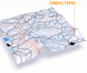 Places with similar names to Chapultepec, Mexico ::
// Chepultepec (US)
// Chapultepec (MX)
// Chapultepec (MX)
// Chapultepec (MX)
// Chapultepec (MX)
// Chapultepec (MX)
// Chapultepec (MX)
// Chapultepec (MX)
// Chapultepec (MX)
// Chapultepec (MX)
Disclaimer :: Information on this page comes without warranty of any kind |
||
|
Where is Chapultepec? Elevation and coordinates ::
Latitude (lat): 19°20'30"N Longitude (lon): 98°0'0"W
Elevation (approx.): 2599m (map arrows pan, magnifying glasses zoom) |
||
|
Visiting Chapultepec? Hotel/Accommodation ::
Book a hotel in Chapultepec Travel Guide ::
Buy a travel guide for Mexico rental cars ::
car rental offers GPS waypoint ::
download a GPX waypoint (PoI) of Chapultepec for your GPS receiver
|
||