|
search place name
|
||
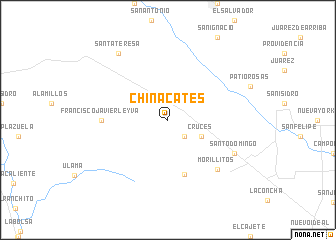
Chinacates (Durango, Mexico)Chinacates is a town in the Durango region of Mexico. An overview map of the region around Chinacates is displayed below.
regional and 3d topo map of Chinacates, Mexico ::
Chinacates airports ::
The nearest airport is DGO - Durango Intl, located 119.5 km south east of Chinacates.
Other airports nearby include TRC - Torreon Intl (192.5 km east), MZT - Mazatlan General Rafael Buelna Intl (229.9 km south west), Nearby towns ::
Las Palmas (2.5km south east) //
Cruces (3.8km south east) //
La Purísima (6.3km south) //
Francisco Javier Leyva (6.7km west) //
Morillitos (7.5km south east) //
Santo Domingo (7.7km south east) //
Santa Teresa (9.0km north west) //
[all distances 'as the bird flies' and approximate] 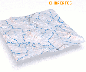 Places with similar names to Chinacates, Mexico ::
// Chinacates (MX)
// Shīn Kats (PK)
// Chingatis (VE)
// Chuang-tzu (TW)
// Chang-ts'o (TW)
// Chang-ts'o (TW)
// Ch'eng-tzu (TW)
// Chiang-ts'o (TW)
// Chiang-ts'o (TW)
// Chiang-ts'ui (TW)
Disclaimer :: Information on this page comes without warranty of any kind |
||
|
Where is Chinacates? Elevation and coordinates ::
Latitude (lat): 25°0'0"N Longitude (lon): 105°13'0"W
Elevation (approx.): 2119m (map arrows pan, magnifying glasses zoom) |
||
|
Visiting Chinacates? Hotel/Accommodation ::
Book a hotel in Chinacates Travel Guide ::
Buy a travel guide for Mexico rental cars ::
car rental offers GPS waypoint ::
download a GPX waypoint (PoI) of Chinacates for your GPS receiver
|
||