|
search place name
|
||
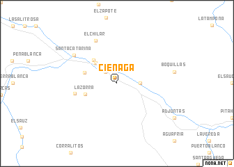
Ciénaga (Querétaro de Arteaga, Mexico)Ciénaga is a town in the Querétaro de Arteaga region of Mexico. An overview map of the region around Ciénaga is displayed below.
regional and 3d topo map of Ciénaga, Mexico ::
Ciénaga airports ::
The nearest airport is QRO - Queretaro Intercontinental, located 56.8 km south of Ciénaga.
Other airports nearby include BJX - Del Bajio Guanajuato Intl (154.4 km west), SLP - San Luis Potosi Ponciano Arriaga Intl (160.0 km north west), TSL - Tamuin (161.5 km north east), PCA - Pachuca Ingeniero Juan Guillermo Villasana (170.1 km south east), Nearby towns ::
La Ordeña (2.5km north west) //
San Miguel Palmas (3.5km east) //
Las Limitas (4.6km north west) //
Cruz de Diego (5.1km north west) //
La Zorra (5.1km west) //
La Faja (5.2km west) //
El Chapín (6.5km west) //
El Chilar (7.6km north west) //
Santa Catarina (7.9km north west) //
[all distances 'as the bird flies' and approximate] 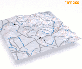 Places with similar names to Ciénaga, Mexico ::
Disclaimer :: Information on this page comes without warranty of any kind |
||
|
Where is Ciénaga? Elevation and coordinates ::
Latitude (lat): 21°6'0"N Longitude (lon): 100°0'0"W
Elevation (approx.): 1725m (map arrows pan, magnifying glasses zoom) |
||
|
Visiting Ciénaga? Hotel/Accommodation ::
Book a hotel in Ciénaga Travel Guide ::
Buy a travel guide for Mexico rental cars ::
car rental offers GPS waypoint ::
download a GPX waypoint (PoI) of Ciénaga for your GPS receiver
|
||