|
search place name
|
||
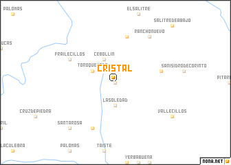
Cristal (Durango, Mexico)Cristal is a town in the Durango region of Mexico. An overview map of the region around Cristal is displayed below.
regional and 3d topo map of Cristal, Mexico ::
Cristal airports ::
The nearest airport is CUL - Culiacan Intl, located 172.4 km south west of Cristal.
Other airports nearby include DGO - Durango Intl (243.5 km south east), Nearby towns ::
Trampa (0.0km north) //
La Soledad (3.7km south) //
Alamillo (4.1km north west) //
Cebollas (4.1km north west) //
Cebollín (4.1km north west) //
Toro Quemado (3.8km north west) //
Llamada (6.9km east) //
Ciénega Amarilla (7.6km north) //
Desechos (8.1km south west) //
Frailecillos (7.6km north west) //
Rancho Nuevo (8.9km north east) //
Santa Rosa (10.0km south west) //
[all distances 'as the bird flies' and approximate] 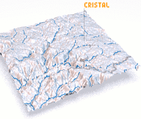 Places with similar names to Cristal, Mexico ::
// Cristal (BR)
// Chrysotile (US)
// Großsattel (AT)
// Crystal (US)
// Crystola (US)
// Greiz-Dölau (DE)
// Grassdale (US)
// Crystal (US)
// Crystal (US)
// Krastel (DE)
Disclaimer :: Information on this page comes without warranty of any kind |
||
|
Where is Cristal? Elevation and coordinates ::
Latitude (lat): 25°45'0"N Longitude (lon): 106°9'0"W
Elevation (approx.): 2717m (map arrows pan, magnifying glasses zoom) |
||
|
Visiting Cristal? Hotel/Accommodation ::
Book a hotel in Cristal Travel Guide ::
Buy a travel guide for Mexico rental cars ::
car rental offers GPS waypoint ::
download a GPX waypoint (PoI) of Cristal for your GPS receiver
|
||