|
search place name
|
||
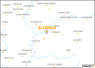
El Capule (Sinaloa, Mexico)El Capule is a town in the Sinaloa region of Mexico. An overview map of the region around El Capule is displayed below.
regional and 3d topo map of El Capule, Mexico ::
El Capule airports ::
The nearest airport is CUL - Culiacan Intl, located 107.1 km north west of El Capule.
Other airports nearby include MZT - Mazatlan General Rafael Buelna Intl (127.7 km south), Nearby towns ::
Potrerillos de los Torres (1.9km south west) //
Lechuguilla (2.6km south west) //
Tasajera (2.9km east) //
El Verano (3.4km north east) //
Playitas (5.5km south west) //
El Río (5.5km north west) //
Guadalupe de los Reyes (5.3km east) //
La Tasajera (5.7km north west) //
Agua Caliente (9.4km south west) //
San Antonio (9.6km north east) //
San Antonio del Río (9.5km north east) //
Los Achotes (10.5km south west) //
Sauz (10.6km south east) //
[all distances 'as the bird flies' and approximate] 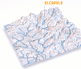 Places with similar names to El Capule, Mexico ::
// El Copalío (SV)
// Elgapalli (IN)
// El Capule (MX)
// El Capule (MX)
// El Capulí (MX)
// El Capullo (MX)
// El Copal (MX)
// El Copal (MX)
// El Copal (MX)
// El Copal (MX)
Disclaimer :: Information on this page comes without warranty of any kind |
||
|
Where is El Capule? Elevation and coordinates ::
Latitude (lat): 24°16'56"N Longitude (lon): 106°33'32"W
Elevation (approx.): 367m (map arrows pan, magnifying glasses zoom) |
||
|
Visiting El Capule? Hotel/Accommodation ::
Book a hotel in El Capule Travel Guide ::
Buy a travel guide for Mexico rental cars ::
car rental offers GPS waypoint ::
download a GPX waypoint (PoI) of El Capule for your GPS receiver
|
||